place

Pwll, Tregare

Country houses in MonmouthshireGrade II* listed buildings in MonmouthshireHistory of Monmouthshire
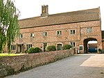
Gateway to The Pwll, Tregare, Monmouthshire

Pwll, Tregare, Monmouthshire is a medieval cruck-house dating from the late 14th century, with additions in the 17th century. An "extremely rare survival", the house was derelict by the mid-20th century, and was reconstructed in the mid-1990s. It is a Grade II* listed building.

Excerpt from the Wikipedia article Pwll, Tregare (License: CC BY-SA 3.0, Authors, Images).

Pwll, Tregare
Pen y Parc Road,

Geographical coordinates (GPS) Address Nearby Places
placeShow on map

Wikipedia: Pwll, TregareContinue reading on Wikipedia

Geographical coordinates (GPS)

Latitude Longitude
N 51.7828 ° E -2.8569 °
placeShow on map

Address

Pen y Parc Road

Pen y Parc Road
NP15 2BY , Mitchel Troy
Wales, United Kingdom
mapOpen on Google Maps

Gateway to The Pwll, Tregare, Monmouthshire
Share experience

Nearby Places

Monmouthshire
Monmouthshire

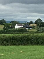
Monmouthshire ( MON-məth-shər, MUN-; Welsh: Sir Fynwy) is a county in the south east of Wales. It borders Powys to the north; the English counties of Herefordshire and Gloucestershire to the north and east; the Severn Estuary to the south, and Torfaen, Newport and Blaenau Gwent to the west. The largest town is Abergavenny, and the administrative centre is Usk. The county is rural, although adjacent to the city of Newport and the urbanised South Wales Valleys; it has an area of 330 square miles (850 km2) and a population of 93,000. After Abergavenny (12,515), the largest towns are Chepstow (12,350), Monmouth (10,508), and Caldicot (9,813). The county has one of the lowest percentages of Welsh speakers in Wales, at 8.2% of the population in 2021.The lowlands in the centre of Monmouthshire are gently undulating, and shaped by the River Usk and its tributaries. The west of the county is hilly, and the Black Mountains in the northwest are part of the Brecon Beacons National Park (Bannau Brycheiniog). The border with England in the east largely follows the course of the River Wye and its tributary, the River Monnow. In the southeast is the Wye Valley AONB, a hilly region which stretches into England. The county has a shoreline on the Severn Estuary, which is crossed at this point by the Severn Bridge and Second Severn Crossing. The name derives from the historic county of the same name, of which the contemporary county covers the eastern three-fifths.