San Martín de Porres Parish (Aragua)
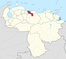
San Martín de Porres Parish is a Venezuelan administrative political division, located in Libertador Municipality, Aragua State, Venezuela and has an approximate population of 130,270 inhabitants. It covers almost 56% of the municipality. The San Martín de Porres Parish limits to the north with the Santa Rita Parish, to the east with the Palo Negro parish, to the south with the Palo Negro Crossroads, and to the west with the Lake of Valencia. The Parish includes: the old Palo Negro-Santa Rita Highway (Aragua), El Libertador Air Base, El Libertador Air Base Urbanization (BAEL), Los Aviadores Socialist City Urbanization, José Antonio Vargas Hospital (La Ovallera Social Security) and La Ovallera Urbanization.
Excerpt from the Wikipedia article San Martín de Porres Parish (Aragua) (License: CC BY-SA 3.0, Authors).San Martín de Porres Parish (Aragua)
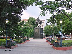
Avenida Güigüe, Parroquia Palo Negro
Geographical coordinates (GPS) Address Nearby Places Show on map
 Continue reading on Wikipedia
 Geographical coordinates (GPS)
| Latitude | Longitude |
|---|---|
| N 10.171111111111 ° | E -67.576388888889 ° |
Address
Seguro Social de La Ovallera
Avenida Güigüe
2117 Parroquia Palo Negro, Base Libertador
Aragua State, Venezuela
Open on Google Maps