Santa Rita, Venezuela
Pages with non-numeric formatnum argumentsPopulated places in AraguaVenezuela geography stubs
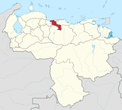
Santa Rita is a city in the state of Aragua, Venezuela. It is the shire town of the Francisco Linares Alcántara Municipality, in the state of Aragua. It is part of the metropolitan area of Maracay. It is 435 meters above sea level and is located in the hydrographic basin of Lake Valencia. Santa Rita is bordered to the north by the Caño Colorado, and the Caracas-Valencia Highway, and to the south by the Turmero River. In 2023 Santa Rita had 149,158 inhabitants.
Excerpt from the Wikipedia article Santa Rita, Venezuela (License: CC BY-SA 3.0, Authors).Santa Rita, Venezuela
Calle El Rosal, Parroquia Palo Negro
Geographical coordinates (GPS) Address Nearby Places Show on map
 Continue reading on Wikipedia
 Geographical coordinates (GPS)
| Latitude | Longitude |
|---|---|
| N 10.200277777778 ° | E -67.551388888889 ° |
Address
Calle El Rosal
Calle El Rosal
2117 Parroquia Palo Negro
Aragua State, Venezuela
Open on Google Maps