place

Church of St Mary, Almer, Dorset

Church of England church buildings in DorsetGrade I listed churches in Dorset
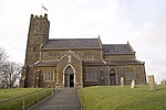
The Parish Church of St Mary, Almer geograph.org.uk 456894

Church of Mary is a Grade I listed church in Almer, Dorset, England. It became a listed building on 18 March 1955. According to Arthur Mee's The King's England: Dorset (ISBN 0-340-00079-1), "the embattled tower is 15th Century, and has a fine arch. In a chancel window is much old glass with fragments of drapery, architecture, and fleur-de-lys; the centre panel has bright-hued glass pictures by Continental artists of the days when men and woman wore stiff ruffs about their necks. One window has what appears to be a group of saints, the other has the Last Judgment, with Our Lord enthroned among angels blowing trumpets. A good soul is being rescued by an angel with lilac wings and a blue dress, while a crimson demon with golden horns is seizing a wicked one."

Excerpt from the Wikipedia article Church of St Mary, Almer, Dorset (License: CC BY-SA 3.0, Authors, Images).

Church of St Mary, Almer, Dorset

Geographical coordinates (GPS) Address External links Nearby Places
placeShow on map

Wikipedia: Church of St Mary, Almer, DorsetContinue reading on Wikipedia

Geographical coordinates (GPS)

Latitude Longitude
N 50.7899 ° E -2.1246 °
placeShow on map

Address

St Mary


DT11 9EP , Sturminster Marshall
England, United Kingdom
mapOpen on Google Maps

linkWikiData (Q17531028)
linkOpenStreetMap (377072506)

The Parish Church of St Mary, Almer geograph.org.uk 456894
Share experience

Nearby Places

Spetisbury railway station

Spetisbury railway station was a station in the English county of Dorset. It was located between Blandford Forum and Bailey Gate on the Somerset and Dorset Joint Railway. The station consisted of two platforms, a station building, signal box and shelters. The ‘down’ platform is the station's original platform, which opened with timber booking office and waiting rooms on 1 November 1860. The platform was extended and a separate brick-built ladies’ waiting room was provided in 1888. The concrete floor and fireplace you see today is the foundation of this building. During reconstruction of the station around 1900 when double track was laid, this platform was again extended to a total length of 300 ft. It then became the ‘down’ platform for trains to Bailey Gate, Broadstone, Poole and Bournemouth (West). You can clearly see the different methods of construction where this platform has been extended.The ‘up’ platform is 300 ft long and was built during reconstruction of the station around 1900. It was used for trains to Blandford, Templecombe, Evercreech Junction (change for the Burnham-on-Sea branch) and Bath (Green Park). This platform opened on 29 April 1901 and was provided with a brick station building containing a booking office, waiting rooms and lavatories. The rear wall of this building still survives as it holds back the field behind the station. The foundations of the various rooms with the three fireplaces can still be seen today.

River Tarrant
River Tarrant

The River Tarrant is a 12 km long tributary of the River Stour in Dorset. The valley lies to the east of Blandford Forum. The river rises near Cranborne Chase, an area of chalk downland, and flows broadly from north to south before joining the river Stour. The eight Tarrant Valley villages/hamlets all bear the name of the river. Listed in order from the river's source they are: Tarrant Gunville: the source of the river is in the grounds of Gunville House, now demolished. The parish church is dedicated to St Mary. Tarrant Hinton: a village at a crossroads. The parish church is dedicated to St Mary. Tarrant Launceston: a hamlet with a 17th-century three-arched bridge. The church, dedicated to St Mary, was demolished in the 1700s (the site is on Higher Dairy Farm). Now part of the parish of Tarrant Monkton. Tarrant Monkton: a village with a parish church dedicated to All Saints. Tarrant Rawston: a very small settlement. This once had a parish church dedicated to St Mary, which still exists and is in private ownership but remains as a church. Tarrant Rushton: a village with a parish church dedicated to St Mary. Near here was a World War II RAF airfield. Tarrant Keyneston: this is the largest village of the eight; it has a parish church dedicated to All Saints. Tarrant Crawford, the final settlement, lies at the confluence of the rivers Tarrant and Stour. Here there is the church of St Mary the Virgin held by the Churches Conservation Trust and Tarrant Abbey farm, where once stood a nunnery. Tarrant Crawford became part of the parish of Tarrant Keyneston.There were possibly one or two other Tarrant communities: Tarrant Stubhampton, north of Tarrant Gunville and part of that parish: This is now known as Stubhampton. In the Middle Ages, a church existed in that village. This is the source of the Tarrant. Tarrant Antioch which may have been an earlier name for Tarrant Rawston, or may have been a distinct community just north of Tarrant Rawston. Tarrant Antioch was served by St Mary Tarrant Crawford, where there was a devotion to St Margaret of Antioch. Tarrant Preston, now Preston FarmA Roman road followed the valley and there are many tumuli on the hills on both sides of the river, evidence of long occupation.