Sonoma Creek

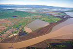
Sonoma Creek is a 33.4-mile-long (53.8 km) stream in northern California. It is one of two principal drainages of southern Sonoma County, California, with headwaters rising in the rugged hills of Sugarloaf Ridge State Park and discharging to San Pablo Bay, the northern arm of San Francisco Bay. The watershed drained by Sonoma Creek is roughly equivalent to the wine region of Sonoma Valley, an area of about 170 square miles (440 km2). The State of California has designated the Sonoma Creek watershed as a “Critical Coastal Water Resource”. To the east of this generally rectangular watershed is the Napa River watershed, and to the west are the Petaluma River and Tolay Creek watersheds. This south flowing river drains the western slopes of the Mayacamas Range, the southern slopes of Annadel State Park and the eastern slopes of the Sonoma Mountains with intermittent winter flows in the higher tributary reaches. As the tributaries and headwaters reach the valley floor, a perennial stream cuts through scenic and valuable vineyards of Kenwood. Sonoma Creek veers west at Kenwood and cuts a gorge running parallel to Warm Springs Road, where it turns south to historic Glen Ellen, passing within one mile (1.6 kilometers) of Jack London State Historic Park and the Wolf House and thence southward paralleling Arnold Drive. In the city of Sonoma it is an urban creek which emerges into agricultural areas to the south. Finally, Sonoma Creek discharges to the vast Napa-Sonoma Marsh at the northern tip of San Pablo Bay. Principal tributaries to the creek include Yulupa Creek, Graham Creek, Calabazas Creek, Bear Creek, Schell Creek, and Fowler Creek.
Excerpt from the Wikipedia article Sonoma Creek (License: CC BY-SA 3.0, Authors, Images).Sonoma Creek
CA 37,
Geographical coordinates (GPS) Address Nearby Places Show on map
Geographical coordinates (GPS)
| Latitude | Longitude |
|---|---|
| N 38.150555555556 ° | E -122.40361111111 ° |
Address
CA 37
California, United States
Open on Google Maps


