Loddon and Clavering Rural District
Districts of England abolished by the Local Government Act 1972Districts of England created by the Local Government Act 1894Historical districts of NorfolkRural districts of EnglandUse British English from June 2017

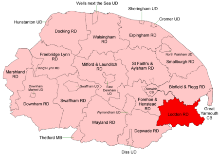
Loddon and Clavering Rural District was a rural district in Norfolk, England from 1894 to 1935., continuing, with very slight boundary changes, as Loddon Rural District until 1974.It was formed under the Local Government Act 1894 based on the Loddon and Clavering rural sanitary district, and took its name from the ancient hundreds of Loddon and Clavering. It lay in the south-east corner of the county. In 1974, the district was abolished under the Local Government Act 1972, and became part of the South Norfolk district.
Excerpt from the Wikipedia article Loddon and Clavering Rural District (License: CC BY-SA 3.0, Authors, Images).Loddon and Clavering Rural District
Leman Grove, South Norfolk
Geographical coordinates (GPS) Address Nearby Places Show on map
Geographical coordinates (GPS)
| Latitude | Longitude |
|---|---|
| N 52.53 ° | E 1.48 ° |
Address
Leman Grove
Leman Grove
NR14 6LH South Norfolk
England, United Kingdom
Open on Google Maps


