Imlay and Laurel Streets District
Historic districts in Hartford County, ConnecticutHistoric districts on the National Register of Historic Places in ConnecticutItalianate architecture in ConnecticutNRHP infobox with nocatNational Register of Historic Places in Hartford, Connecticut ... and 1 more
Queen Anne architecture in Connecticut

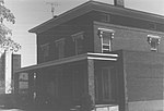
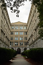
The Imlay and Laurel Streets District is a residential historic district on portions of Imlay, Laurel, Hawthorn and Sigourney Streets in Hartford, Connecticut. The area is a densely built residential neighborhood developed between about 1870 and 1895, with predominantly brick Italianate and Queen Anne construction. The district was listed on the National Register of Historic Places in 1979.
Excerpt from the Wikipedia article Imlay and Laurel Streets District (License: CC BY-SA 3.0, Authors, Images).Imlay and Laurel Streets District
Imlay Street, Hartford
Geographical coordinates (GPS) Address External links Nearby Places Show on map
Geographical coordinates (GPS)
| Latitude | Longitude |
|---|---|
| N 41.765833333333 ° | E -72.696111111111 ° |
Address
Imlay and Laurel Streets District
Imlay Street
06105 Hartford
Connecticut, United States
Open on Google Maps


