place

Deer Flat National Wildlife Refuge

1909 establishments in Idaho1909 establishments in OregonCivilian Conservation Corps in IdahoIUCN Category IVLandforms of Baker County, Oregon
Landforms of Canyon County, IdahoLandforms of Malheur County, OregonLandforms of Owyhee County, IdahoLandforms of Payette County, IdahoLandforms of Washington County, IdahoNational Wildlife Refuges in IdahoNational Wildlife Refuges in OregonProtected areas established in 1909Protected areas of Baker County, OregonProtected areas of Canyon County, IdahoProtected areas of Malheur County, OregonProtected areas of Owyhee County, IdahoProtected areas of Payette County, IdahoProtected areas of Washington County, IdahoSnake RiverWetlands of IdahoWetlands of OregonWorks Progress Administration in Idaho
Lake Lowell, Idaho in summer

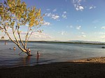
The Deer Flat National Wildlife Refuge is an important breeding area for mammals, birds, and other animals. The National Wildlife Refuge is located on land surrounding Lake Lowell, just outside Nampa, Idaho. It serves as a resting and wintering area for birds, including mallards and Canada geese, along the Pacific Flyway and was named a "Globally Important Bird Area" by the American Bird Conservancy.The refuge consists of two sections which contains open water, edge wetlands, grasslands and riparian and forest habitats. The largest portion of the refuge consists of Lake Lowell and its environs, located in Canyon County, just west of Nampa, while the second comprises the Snake River islands located in non-contiguous localities along the river in Canyon, Owyhee, Payette, and Washington counties (Idaho) and Malheur and Baker counties (Oregon). There is a visitor center at the Lake Lowell site, which is the hub of activity for visitors and those volunteers who donate their time and services to wildlife conservation projects.

Excerpt from the Wikipedia article Deer Flat National Wildlife Refuge (License: CC BY-SA 3.0, Authors, Images).

Deer Flat National Wildlife Refuge

Geographical coordinates (GPS) Address Nearby Places
placeShow on map

Wikipedia: Deer Flat National Wildlife RefugeContinue reading on Wikipedia

Geographical coordinates (GPS)

Latitude Longitude
N 43.55 ° E -116.66666666667 °
placeShow on map

Address

Canyon County (Canyon)


Idaho, United States
mapOpen on Google Maps

Lake Lowell, Idaho in summer
Share experience

Nearby Places

Deer Flat Upper Embankment

Deer Flat Upper Embankment (National ID # ID00276) is a dam in the western United States in southwestern Idaho. Located in the Treasure Valley in Canyon County, it is directly southwest of Nampa. The earthen dam was completed 116 years ago in 1908 by the Reclamation Service (now U.S. Bureau of Reclamation), with a height of 74 feet (23 m) and a crest length of 4,165 feet (1.27 km). The Upper Embankment is the largest of a set of four dikes here impounding the water of the Boise River in offstream storage. The other dams are: Deer Flat Middle Dike (ID #ID00277), completed 1911, 18 feet (5.5 m) high, 1,262 feet (385 m) long Deer Flat Lower Dike (ID #ID00278), completed 1908, 48 feet (15 m) high, 7,270 feet (2,220 m) long Deer Flat East Dike (ID #ID82902), completed 1911, 18 feet (5.5 m) high, 3,806 feet (1,160 m) longThe reservoir it creates, Lake Lowell, has a normal surface area of 16 square miles (41 km2), and a maximum capacity of 169,000 acre-feet (208,000,000 m3). Its surface elevation is approximately 2,520 feet (770 m) above sea level. The Boise Project was among the first undertaken by the Reclamation Service after its formation in 1902. Shortly before leaving office, President Theodore Roosevelt created a national bird refuge at Deer Flat Reservoir, now Lake Lowell, with an executive order on February 25, 1909. The refuge was one of 17 federal reclamation projects referenced in the order, each of which used manmade aquifers to provide safe havens for migratory birds. The effort to include the Canyon County site was spearheaded by James H. Lowell, the president of the local Payette-Boise Water Users Association. The "globally important" Deer Flat National Wildlife Refuge for migratory fowl and other wildlife consists of two sections which contains open water, edge wetlands, grasslands and riparian and forest habitats. The largest portion of the refuge consists of Lake Lowell and its environs. The second portion comprises the Snake River islands located in non-contiguous localities along the river in Canyon, Owyhee, Payette, and Washington counties (Idaho) and Malheur and Baker counties (Oregon). The visitors' center on the northern Lake Lowell shoreline is the hub of activity for visitors and those volunteers who donate their time and services to wildlife conservation projects.