place

Midford railway station

Beeching closures in EnglandCombe DownDisused railway stations in SomersetFormer Somerset and Dorset Joint Railway stationsPages with no open date in Infobox station
Railway stations in Great Britain closed in 1966Railway stations in Great Britain opened in 1874Use British English from January 2018
Midford Railway Station

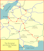
Midford railway station was a single-platform station on the Bath extension of the Somerset and Dorset Railway, just to the north of the point where the double-track became a single track. It served the village of Midford. The station was closed with the rest of the line in March 1966 under the Beeching axe, though it had been unstaffed for some years before that. There was a small goods yard to the north of the station, towards the entrance to the Combe Down Tunnel, which loaded Fuller's earth from Tucking Mill. South of the station, a signal box presided over the double track junction: the railway then ran across the Midford valley on a high viaduct that still exists. For about four years from 1911 to 1915, Midford had a second railway station, Midford Halt located on the GWR Camerton Branch, which passed under the S&DJR viaduct.

Excerpt from the Wikipedia article Midford railway station (License: CC BY-SA 3.0, Authors, Images).

Midford railway station
Old Frome Road,

Geographical coordinates (GPS) Address Nearby Places
placeShow on map

Wikipedia: Midford railway stationContinue reading on Wikipedia

Geographical coordinates (GPS)

Latitude Longitude
N 51.3449 ° E -2.3452 °
placeShow on map

Address

The Hope & Anchor Car Park

Old Frome Road
BA2 7BZ
England, United Kingdom
mapOpen on Google Maps

Midford Railway Station
Share experience

Nearby Places

Wellow Brook
Wellow Brook

The Wellow Brook is a small river in Somerset, England. It rises near Ston Easton Park in the village of Ston Easton and flows east to Midsomer Norton. West of Radstock, it is joined by the River Somer and a tributary from Kilmersdon (formed itself from Snails Brook and Kilmersdon Brook) to the south. It then flows through Wellow before joining the Cam Brook at Midford to form Midford Brook, before joining the River Avon close to the Dundas Aqueduct. The Environment Agency does not recognise the Midford Brook, instead identifying the Wellow Brook as continuing to the Avon. On this basis the length of the Wellow Brook, from Radstock to the Avon, is 17.8 km (11.1 mi).Alongside the brook are remains of the Somerset Coal Canal which served the Somerset Coalfield in the 19th century. The valley sides are rounded and undulating through erosion. There are several springs dotted along the valley sides and the resultant streams are often lined with trees. The junction of the valley sides with the base is usually gentle and rounded and the valley floors are narrow but flat with the brooks meandering freely across their flood plain. The brook is quite deep in places and frequently has steep sides. This was taken advantage of in making anti-tank defences during World War II when many concrete bunkers known as pillboxes were built as part of the GHQ Line to defend against an expected German invasion.The area is of interest to the Cam Valley Wildlife Group.

Midford Castle
Midford Castle

Midford Castle is a folly castle in the village of Midford, and the parish of Southstoke 3 miles (5 km) south of Bath, Somerset, England. The castle was built in 1775 for Henry Disney Roebuck from designs by John Carter in the shape of the "clubs" symbol used in playing cards (♣). It has been suggested, originally in a magazine article in 1899, that he asked for the clubs design to represent an ace of clubs because he had obtained the money for the castle from gambling on a card game, but this is unlikely, as the porch which creates the "stem" of the symbol was added later. It is more likely that the layout was taken from an article which had been published in Builder's Magazine in 1774. The house has a sub triangular or trefoil plan formed by 3 semi-circular towers conjoined in a gothic style. It has been designated by English Heritage as a Grade I listed building.In 1810, the castle was bought by one of the Conollys of Castletown House in County Kildare, who added the porch (said to give the clubs symbol its stalk) and built the nearby stables and chapel, known as the priory. The latter fell into disrepair after the last of the Conollys sold the house in 1901.Soon after 1810 Kingham Field, which was part of the estate, was operating as a stone quarry similar to the nearby Combe Down and Bathampton Down Mines. William Smith, who became known as "Father of English Geology", proposed conveying the stone by a railway down to Tucking Mill where it would be sawn by machinery, and then loaded on to canal barges and transported via the Somerset Coal Canal and the Kennet and Avon Canal to Bath and London. In April 1814, Smith mortgaged the remainder of his estate to Charles Conolly who then controlled the railway and probably extended it to his Vinegar Down Quarry. The scheme failed and in 1819 Conolly had Smith committed to the King's Bench Prison for debt and took over the sawmill and Smith's house at Tucking Mill.Michael Fenwick Briggs and his wife Isabel (better known by her pen name of Isabel Colegate) bought Midford in 1961 and carried out extensive renovation work; which included incorporating the chapel into the garden as a picturesque ruin.In July 2007, the castle was sold to actor Nicolas Cage for £5 million. Cage sold the castle in 2009.The castle is listed Grade I on the National Heritage List for England. The castle grounds also include the Grade II listed archway with lodge and screen wall, a pair of gatepiers and gates, and the Grade II* listed group of the stables, old chapel, walls enclosing the stable yard, coach house and greenhouse. The priory 500 yards to the north east of the castle is Grade II listed.