place

Sheppard Avenue Bridge
Bridges in TorontoCanadian bridge (structure) stubsOntario building and structure stubsOntario transport stubsRoad bridges in Ontario
Toronto stubs
Sheppard Avenue Bridge

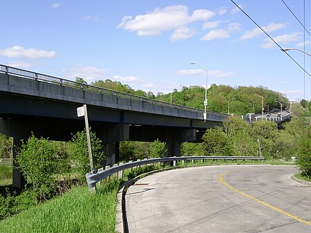
Sheppard Avenue Bridge is an under deck Truss bridge that spans the Don River on Sheppard Avenue West, just east of Bathurst Street in Toronto, Ontario, Canada. Built in 1954, the bridge has a scenic view of the West Don River and Earl Bales Park. The current bridge replaced an old concrete bridge that was damaged during Hurricane Hazel and required cars to descend down the valley.The upper deck carries four lanes of traffic. There is a water main in the steel sub-structure. In April 2006, a small section of the road collapsed due to a break in the 50-year-old water main carried below. The bridge was out of commission for three weeks.The bridge is the last major bridge to span the West Don River before it is diverted under most roads north of Sheppard with metal or concrete culverts. Several smaller concrete bridges traverse over the East Don River (with one larger bridge on Eglinton Avenue near the Don Valley Parkway) northwards towards the city limits at Steeles Avenue.

Excerpt from the Wikipedia article Sheppard Avenue Bridge (License: CC BY-SA 3.0, Authors, Images).

Sheppard Avenue Bridge
Sheppard Avenue West, Toronto

Geographical coordinates (GPS) Address Nearby Places
placeShow on map

Wikipedia: Sheppard Avenue BridgeContinue reading on Wikipedia

Geographical coordinates (GPS)

Latitude Longitude
N 43.757 ° E -79.43 °
placeShow on map

Address

Sheppard Avenue West
M2N 1N5 Toronto (North York)
Ontario, Canada
mapOpen on Google Maps

Sheppard Avenue Bridge
Share experience

Nearby Places

Armour Heights Field

Armour Heights Field was home to a Royal Flying Corps airfield in Toronto, Ontario, Canada during World War I, and was one of three in the area. Many RFC (later, Royal Air Force) pilots trained in Canada due to space availability. The airfield was opened in July 1917, but closed in 1919 as the war had ended. It was later developed as a residential development and remains as such today. In 1917, an airfield was constructed near the site of the present Avenue Road and Route 401 interchange, and early the following year, the School of Special Flying opened. Student pilots received instruction on the basics of flight, aerial reconnaissance and aerial combat. However, the school had a short life as it closed around the time the Armistice was signed, on November 11, 1918. The airfield had six hangars and a smaller structure housing offices.In 1919, Bishop-Barker Airplanes Limited, founded by World War I Royal Flying Corps veterans William "Billy" Bishop and William Barker, took over the aerodrome. This business venture was also short-lived, closing in 1921, and one of Canada's busiest airfields at the time was simply abandoned. Evidence of the field's tarmac was still visible until late 2015 on Ravenhill Road, but was paved over shortly after. This was the last piece of visual evidence of the aerodrome's existence. The site is now the Canadian Forces College, which teaches the Command and Staff courses to officers of all three service branches. The only remnant of the Royal Flying Corps days is the stone building currently housing the Armour Heights Officers Mess, a Tudor-Revival home built in 1914 by George and Moorhouse Architects for Colonel Frederick Burton Robins (1866-1948), Honorary Colonel of the Toronto Scottish Regiment and real estate developer. Robins had acquired the land from family of original settler John Armour, for whom the area is now named.