Kópavogur
Iceland geography stubsKópavogurMunicipalities of IcelandPopulated places in Capital Region (Iceland)Southwest Iceland

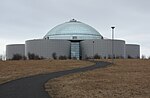
Kópavogur (Icelandic pronunciation: [ˈkʰouːpaˌvɔːɣʏr̥]) is a town in Iceland that is the country's second largest municipality by population. It lies immediately south of Reykjavík and is part of the Capital Region. The name literally means seal pup inlet. The town seal contains the profile of the church Kópavogskirkja with a seal pup underneath. Kópavogur is largely made up of residential areas, but has commercial areas and much industrial activity as well. The tallest building in Iceland, the Smáratorg Tower, is located in central Kópavogur.
Excerpt from the Wikipedia article Kópavogur (License: CC BY-SA 3.0, Authors, Images).Kópavogur
Zeller Straße, Sigmarszell (VGem)
Geographical coordinates (GPS) Address Nearby Places Show on map
 Continue reading on Wikipedia
 Geographical coordinates (GPS)
| Latitude | Longitude |
|---|---|
| N 64.110833333333 ° | E -21.909444444444 ° |
Address
Zeller Straße 15
88138 Sigmarszell (VGem)
Bayern, Deutschland
Open on Google Maps