Altes Schloss (Drügendorf)
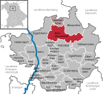
The small ringwork of the Altes Schloss ("old castle") is all that remains of a, now levelled, early medieval fortification on one of the projecting hill spurs of the Mirsberg Heights (Mirsberger Höhe) on the Lange Meile in the valley of the Eggerbach. The spur is called the Schlossberg ("castle hill"). The old castle site lies at a height of 493.4 m above sea level (NN) around 935 metres south-southeast of the Roman Catholic parish church of St. Margareta of Drügendorf in the Upper Franconian municipality of Eggolsheim in Bavaria, Germany. No historical or archaeological information about this hillfort exists, and there have been no finds that might be able to be used to date the site. Based on the design of the fortification it has been tentatively dated to the Carolingian-Ottonian period. All that has survived is a ringwork with an outer ditch in places. The fortification is protected today as heritage site number D-4-6132-0125: "Early Medieval Ringwork" (Frühmittelalterliche Ringwallanlage).
Excerpt from the Wikipedia article Altes Schloss (Drügendorf) (License: CC BY-SA 3.0, Authors).Altes Schloss (Drügendorf)
FO 41,
Geographical coordinates (GPS) Address Nearby Places Show on map
Geographical coordinates (GPS)
| Latitude | Longitude |
|---|---|
| N 49.799388 ° | E 11.122378 ° |
Address
Altes Schloss
FO 41
91330
Bavaria, Germany
Open on Google Maps


