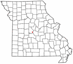
Mill Creek (Morgan County, Missouri)
Mill Creek is a stream in Morgan County in the U.S. state of Missouri. It is a tributary to the Gravois Creek arm of the Lake of the Ozarks.The stream headwaters arise at 38°14′23″N 92°53′10″W just northeast of Missouri Route 135 at an elevation of approximately 920 ft (280 m). The stream meanders northeast and east passing under Missouri Route 5 and enters the Lake of the Ozarks at 38°14′37″N 92°48′02″W at an elevation of 663 ft (202 m). Previous to the impoundment of the lake the confluence of Mill Creek with Gravois Creek was located 2.3 miles to the northeast at 38°15′32″N 92°45′15″W and an elevation of 620 ft (190 m) and about one mile north of the community of Gladstone.Mill Creek was so named on account of watermills near its course.
Excerpt from the Wikipedia article Mill Creek (Morgan County, Missouri) (License: CC BY-SA 3.0, Authors).Mill Creek (Morgan County, Missouri)
Ranch Road,
Geographical coordinates (GPS) Address Nearby Places Show on map
Geographical coordinates (GPS)
| Latitude | Longitude |
|---|---|
| N 38.243611111111 ° | E -92.800555555556 ° |
Address
Ranch Road
Ranch Road
65037
Missouri, United States
Open on Google Maps


