place

Christchurch Gondola

1992 establishments in New ZealandGondola lifts in New ZealandTourist attractions in ChristchurchTransport in ChristchurchUse New Zealand English from January 2018
Christchurch gondola 02

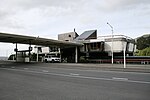
The Christchurch Gondola is a tourist attraction service offered by Christchurch Attractions in Christchurch, New Zealand. The gondola base is located in Heathcote Valley, and it traverses the slopes of Mount Cavendish in the Port Hills. Also known as a cable car, the Christchurch Gondola's course is 1,000 metres (1,100 yd) in length, and from the summit it is possible to see across the city of Christchurch and the Canterbury Plains to the Southern Alps in the north and west, and down into Lyttelton Harbour and Banks Peninsula in the south and east. Sometimes used as a transport method for visitors who use the walking tracks on Mt Cavendish, the gondola is ranked as one of the top tourist attractions in Christchurch by TripAdvisor. The summit is 445 metres (1,460 ft) above sea level.The gondola opened as the Mount Cavendish Gondola in October 1992 after a long planning process at a costs of $NZ11.5 million. The land around the gondola was landscaped with 16,000 native tussock after the completion of construction. The gondola includes 19 cabins and has a capacity of 812 travellers per hour.

Excerpt from the Wikipedia article Christchurch Gondola (License: CC BY-SA 3.0, Authors, Images).

Christchurch Gondola
Bridle Path Road, Linwood-Central-Heathcote Community Heathcote

Geographical coordinates (GPS) Address Nearby Places
placeShow on map

Wikipedia: Christchurch GondolaContinue reading on Wikipedia

Geographical coordinates (GPS)

Latitude Longitude
N -43.585 ° E 172.70805555556 °
placeShow on map

Address

Christchurch Gondola (Gondola ride)

Bridle Path Road 10
8082 Linwood-Central-Heathcote Community, Heathcote
Canterbury, New Zealand
mapOpen on Google Maps

Christchurch gondola 02
Share experience

Nearby Places

Bridle Path (New Zealand)

The Bridle Path is a steep shared-use track that traverses the northern rim of the Lyttelton volcano connecting the port of Lyttelton with the city of Christchurch in the South Island of New Zealand. It is a popular walking and mountain biking route. The track ascends from the port itself to a height of 333 metres (1,093 ft) before descending again via Heathcote Valley to Christchurch. At the summit, next to the Summit Road, is a stone shelter with covered seats that is a 1940 New Zealand centennial memorial to the Pioneer Women of Canterbury. There are also seven commemorative stone seats placed along the Bridle Path; most of these were built for the 1950 Canterbury centenary celebrations. Hastily constructed in late 1850, just in time for the first Canterbury Association settlers to use, it was the most direct way to travel from the port to the new settlements on the plains on the northern side of the Port Hills. Although very steep, it was the primary means of traversing the hills until the Sumner Road over Evans Pass was opened to light traffic in 1858. Originally, the road over Evans Pass was intended to be completed by the time the first settlers arrived but the Canterbury Association ran out of money. John Robert Godley had the road work stopped, and only had enough time to cut a rough Bridle Road once obtained further funding. It is referred to as a bridle path because the track was so steep and narrow in places that riders needed to dismount and lead their horses by the bridle. The path was considered unsuitable for a fully loaded cart or dray. The track is a legal road, so may be used by motor vehicles, such as trail bikes, though this is regarded as a nuisance. There have been attempts to change the legal status from road to park since the 1970s.