Winshill
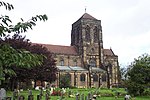
Winshill is an area to the east of the town of Burton upon Trent, in the borough of East Staffordshire, England. Flanked to the north and east by the South Derbyshire border, historically the parish of Winshill had always been part of Derbyshire until it was transferred to Staffordshire, in part in 1878, and wholly in 1894.Along its southern flank runs the A511, known locally as the Ashby Road, from Bretby Lane and Moat Bank (Burton upon Trent's highest point) to the eastern end of the Trent Bridge and the junction with the A444. Along its western flank are the River Trent and the B5008 Newton Road, which runs to Newton Solney and Repton in South Derbyshire. The parish church in Winshill is St Mark's, part of the Diocese of Derby.
Excerpt from the Wikipedia article Winshill (License: CC BY-SA 3.0, Authors).Winshill
Fairham Road, East Staffordshire Stretton
Geographical coordinates (GPS) Address Nearby Places Show on map
Geographical coordinates (GPS)
| Latitude | Longitude |
|---|---|
| N 52.835 ° | E -1.621 ° |
Address
Fairham Road
Fairham Road
DE13 0BU East Staffordshire, Stretton
England, United Kingdom
Open on Google Maps


