place

Hooker Valley Track

Aoraki / Mount Cook National ParkGeographic coordinate listsHiking and tramping tracks in Canterbury, New ZealandLists of coordinates
Stocking Stream Shelter in Hooker Valley in front of Aoraki Mount Cook Range

The Hooker Valley Track is the most popular short walking track within the Aoraki / Mount Cook National Park in New Zealand. At only 5 kilometres (3.1 mi) length and gaining only about 100 m (330 ft) in height, the well formed track can be walked by tourists with a wide range of level of fitness.The track is maintained by the Department of Conservation and has views of Aoraki / Mount Cook and access to the proglacial Hooker Lake, typically with icebergs floating in it. Hooker Valley Track has been named one of the 'best day walks in New Zealand'.The lookout point at the end of the Hooker Valley Track is the closest any walking track comes to Aoraki / Mount Cook, and reveals completely unobstructed views of the highest mountain in New Zealand, with Hooker Glacier in the valley below. There is also access to the shore of the glacial lake. The vegetation around the track is open alpine tussock, and as such the track offers clear views of the mountains surrounding the wide valley floor of the Hooker Valley.

Excerpt from the Wikipedia article Hooker Valley Track (License: CC BY-SA 3.0, Authors, Images).

Hooker Valley Track
Hooker Valley Track,

Geographical coordinates (GPS) Address Nearby Places
placeShow on map

Wikipedia: Hooker Valley TrackContinue reading on Wikipedia

Geographical coordinates (GPS)

Latitude Longitude
N -43.6949 ° E 170.0968 °
placeShow on map

Address

Hooker Valley Track

Hooker Valley Track
7946
Canterbury, New Zealand
mapOpen on Google Maps

Stocking Stream Shelter in Hooker Valley in front of Aoraki Mount Cook Range
Share experience

Nearby Places

Aoraki / Mount Cook National Park

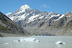
Aoraki / Mount Cook National Park is a national park located in the central-west of the South Island of New Zealand. Aoraki / Mount Cook, New Zealand's highest mountain, and Mount Cook Village lie within the park. The area was gazetted as a national park in October 1953 and covers 707 km2 (273 sq mi). Aoraki / Mount Cook National Park borders Westland Tai Poutini National Park along the Main Divide of the Southern Alps. The national park consists of reserves that were established as early as 1885 to protect the area's significant landscape and vegetation. Many of the geographical features in the park were named by or for early European surveyors and explorers. Following the Ngāi Tahu Claims Settlement Act 1998, the name of the of the national park and geographical features of Ngāi Tahu's takiwā (tribal area) were officially changed in October 1998 to recognise their historic Māori name. Glaciers cover 40% of the park area. Notably, the county's largest glacier—Haupapa / Tasman Glacier—lies within the national park. In the nearby Mackenzie Basin, Māori would burn tōtara forests to assist them with their hunting of moa and gathering food before heading west in search of pounamu, however there is no evidence of permanent or temporary Māori settlement within the national park. The park is managed by the Department of Conservation (DOC) and acknowledges the Ngāi Tahu iwi who hold mana whenua status of the land along with Te Wāhipounamu, a UNESCO World Heritage Site established in 1990. The national park is home to more than four hundred species of plants, including more than one hundred introduced species. There are about thirty-five species of birds in the park, including the rare black stilt and pīwauwau. 
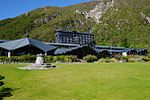
At the end of the most recent ice age, around 13,000 years ago, numerous glaciers in the park were tributaries of a much larger glacier covering all of Hooker Valley and Tasman Valley in hundreds of metres of ice. This glacier was about 85 km (53 mi) long and reached beyond the southern end of today's Lake Pukaki, up to 40 km (25 mi) south of Aoraki / Mount Cook National Park. As the glacier retreated, it filled the hollowed-out valleys, leaving behind the flat-bottomed U-shaped valleys seen today in the national park. Most of the park is alpine terrain, The only road access into Aoraki / Mount Cook National Park is via State Highway 80 which starts 65 km (40 mi) away near Twizel—the closest town to the park—that leads directly to Mount Cook Village along the western shore of Lake Pukaki. There is a small airfield situated within the national park—Mount Cook Aerodrome—which is located 5 km (3.1 mi) southeast of Mount Cook Village. There are numerous walking tracks in the national park—most popular being the Hooker Valley Track—which is a relatively short walking track and takes typically three hours to complete. In addition to short walks and hikes, other popular activities include boat tours, hunting, kayaking, mountaineering, and ski-touring. The park is popular with astrophotographers and star-gazers because it has a clear atmosphere and low levels of light pollution. Aoraki / Mount Cook National Park and the Mackenzie Basin were designated as the Aoraki Mackenzie International Dark Sky Reserve in June 2012.

Copland Pass
Copland Pass

The Copland Pass (el. 2,150 metres or 7,050 feet) is an alpine pass in the Southern Alps of New Zealand. Known as Noti Hinetamatea by the indigenous Ngāi Tahu, the pass follows the route of the Makaawhio ancestor Hinetamatea and her sons Tātāwhākā and Marupeka.The Copland Pass is on a traditional tramping route connecting Mount Cook Village with the West Coast of New Zealand, 26 kilometres (16 mi) south of Fox Glacier. The Copland Pass is located on the Main Divide and is thus located on the boundary of Aoraki / Mount Cook and Westland Tai Poutini National Parks.The Copland River on the western side of the Main Divide may have been named by the surveyor J. G. Roberts for Dr James Copland, an early settler in Otago. Edward FitzGerald and Matthias Zurbriggen crossed the Main Divide just 500 metres (1,600 ft) further south in February 1895 and that pass, with an elevation of 2,109 metres (6,919 ft), has been named FitzGerald Pass. A month later, the mountaineer Arthur Paul Harper was the first non-Māori man to cross the slightly higher Copland Pass (2,150 metres or 7,050 feet) and he named it for the main river draining its western side. Jane Thomson was the first non-Māori woman to cross the pass in 1903.Since the mid-1990s, the eastern climb towards the pass has experienced heavy erosion, and the Copland Pass has become extremely difficult to climb. The Department of Conservation advises that only parties with a "high level of mountaineering experience and appropriate mountaineering equipment" should attempt the crossing, and that numerous fatalities have occurred over the years. Furthermore, crossings should only be attempted from east to west. The Hooker Hut on the eastern side of the pass, which was on the traditional route for the crossing, is no longer accessible, but is stranded on an eroding moraine.