place

Weston, Winnipeg

Manitoba geography stubsNeighbourhoods in Winnipeg

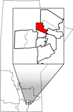
Weston is a neighbourhood in Winnipeg, Manitoba, Canada, located south of the Canadian Pacific Railway Weston Yards, west of McPhillips Street, north of Notre Dame Avenue, and east of Keewatin Street. It is a working-class residential and industrial district with some retail establishments along Logan Avenue and on Keewatin Street. Historically, the neighbourhood was nicknamed "CPR Town" due to the large number of railway workers who resided there. As the number of jobs at the Weston Shops declined, correspondingly, so did the neighbourhood. About 80% of the housing stock was constructed before 1960.

Excerpt from the Wikipedia article Weston, Winnipeg (License: CC BY-SA 3.0, Authors).

Weston, Winnipeg
William Avenue West, Winnipeg

Geographical coordinates (GPS) Address Nearby Places
placeShow on map

Wikipedia: Weston, WinnipegContinue reading on Wikipedia

Geographical coordinates (GPS)

Latitude Longitude
N 49.916111111111 ° E -97.19 °
placeShow on map

Address

William Avenue West
R3H 0J9 Winnipeg
Manitoba, Canada
mapOpen on Google Maps

Share experience

Nearby Places

Wellington (Manitoba provincial electoral district)

Wellington was a provincial electoral division in the Canadian province of Manitoba. It was first created by redistribution in 1957, and formally came into being in the provincial election of 1958. The riding was eliminated in 1979, but was re-established in 1989. It was eliminated again for the 2011 election. It is located in the northwestern section of the city of Winnipeg, and is named after Arthur Wellesley, 1st Duke of Wellington. Wellington was bordered on the east by Point Douglas, to the south by Minto and St. James, to the north by Inkster and Burrows, and to the west by the rural riding of Lakeside. The riding's population in 1996 was 20,283. In 1999, the average family income was $32,907, with 43% of the riding's residents listed as low-income (the third highest in the province). The unemployment rate is 16%. Over 45% of the riding's dwellings are rental units, and one family in four is single-parent. Wellington's ethnic base was diverse. Seventeen per cent of its residents were aboriginal, 15% Filipino, 7% Portuguese, 3% Chinese and 2% East Indian. Manufacturing accounted for 27% of Wellington's industry, with a further 16% in services. The riding was held by the Progressive Conservatives from 1958 to 1966. The NDP won the seat in 1966, and held it until the riding's dissolution in 1981. They also won every election since the riding's re-emergence in 1990. It was considered a safe seat for the party. In 2003, veteran MLA Conrad Santos was re-elected for the riding with almost 75% of the vote. Following the 2008 electoral redistribution, the riding was dissolved into St. James, Minto, and the new ridings of Tyndall Park (electoral district) and Logan. This change took effect for the 2011 election.

Burrows (electoral district)

Burrows is a provincial electoral division in the Canadian province of Manitoba. It was created by redistribution in 1957 from part of Winnipeg North, and formally came into existence in the provincial election of 1958. The riding is located in the northern part of Winnipeg. Burrows is named after Theodore Arthur Burrows, who served as Lieutenant-Governor of Manitoba from 1926 to 1929. It is bordered to the east by St. Johns and Point Douglas, to the south by Wellington, to the north by Kildonan and The Maples, and to the west by Tyndall Park. The riding's boundaries were significantly redrawn in 1999, taking in a considerable amount of territory which was previously a part of the now-defunct Inkster. The riding's population in 1996 was 18,718. In 1999, the average family income was $35,575, one of the lowest rates in the province. Thirty-nine per cent of the riding's residents are listed as low-income, with an unemployment rate of 13%. One household in four has only one parent. Nineteen per cent of the riding's residents are over sixty-five years of age. The total immigrant population in Burrows is 21%, with almost one in three residents speaking a first language other than English or French. The Aboriginal population is 15%. Manufacturing accounts for 22% of Burrows' industry, with a further 15% in the service sector. The CCF and its successor the NDP have won Burrows on all but three occasions since the riding was created, with the Liberals winning the other three elections.