place

Camp White Station Hospital Administration Building

1942 establishments in OregonBuildings and structures completed in 1942Colonial Revival architecture in OregonNational Register of Historic Places in Jackson County, OregonWhite City, Oregon
Camp White Station Hospital Administration Building 2 White City Oregon

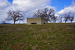
The Camp White Station Hospital Administration Building is a historic government building in White City, Oregon. It is also known as Building 200 of the Southern Oregon - White City VA Rehabilitation Center & Clinics, located at 8495 Crater Lake Highway. It is a two-story brick building with modest Colonial Revival features, built in 1942 as part of the Camp White training base. Its original purpose was to house the administration of the base's hospital, and it has continued to house medical administrative facilities for the United States Department of Veterans Affairs in the years following World War II. It is the best-preserved of the base's hospital buildings, and was listed on the National Register of Historic Places in 2016.

Excerpt from the Wikipedia article Camp White Station Hospital Administration Building (License: CC BY-SA 3.0, Authors, Images).

Camp White Station Hospital Administration Building
Crater Lake Highway,

Geographical coordinates (GPS) Address Phone number Website Nearby Places
placeShow on map

Wikipedia: Camp White Station Hospital Administration BuildingContinue reading on Wikipedia

Geographical coordinates (GPS)

Latitude Longitude
N 42.440833333333 ° E -122.84027777778 °
placeShow on map

Address

White City VA Rehabilitation Center & Clinics

Crater Lake Highway 8495
97503
Oregon, United States
mapOpen on Google Maps

Phone number

call+15418262111

Website
southernoregon.va.gov

linkVisit website

Camp White Station Hospital Administration Building 2 White City Oregon
Share experience

Nearby Places

Little Butte Creek
Little Butte Creek

Little Butte Creek is a 17-mile-long (27 km) tributary of the Rogue River in the U.S. state of Oregon. Its drainage basin consists of approximately 354 square miles (917 km2) of Jackson County and another 19 square miles (49 km2) of Klamath County. Its two forks, the North Fork and the South Fork, both begin high in the Cascade Range near Mount McLoughlin and Brown Mountain. They both flow generally west until they meet near Lake Creek. The main stem continues west, flowing through the communities of Brownsboro, Eagle Point, and White City, before finally emptying into the Rogue River about 3 miles (5 km) southwest of Eagle Point. Little Butte Creek's watershed was originally settled by the Takelma, and possibly the Shasta tribes of Native Americans. In the Rogue River Wars of the 1850s, most of the Native Americans were either killed or forced onto Indian reservations. Early settlers named Little Butte Creek and nearby Big Butte Creek after their proximity to Mount McLoughlin, which was known as Snowy Butte. In the late 19th century, the watershed was primarily used for agriculture and lumber production. The city of Eagle Point was incorporated in 1911, and remains the only incorporated town within the watershed's boundaries. Large amounts of water are diverted from Little Butte Creek for irrigation, water storage, and power generation. Canal systems deliver the water to nearby Howard Prairie Lake and the Klamath River watershed, Agate Lake, and the Rogue Valley. Despite being moderately polluted, the creek is one of the best salmon-producing tributaries of the Rogue River. Coho and Chinook salmon migrate upstream each year; however, several dams hinder their progress. A fish ladder was built in 2005 to help fish swim past a dam constructed in Eagle Point in the 1880s, but was destroyed by flooding just three months later. It was rebuilt in 2008. Restoration of a 1.3-mile (2.1 km) artificially straightened section of the creek in the Denman Wildlife Area was completed in 2011.