place

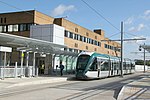
Gregory Street tram stop

Nottingham Express Transit stopsPages with no open date in Infobox stationRailway stations in Great Britain opened in 2015Use British English from June 2017
Gregory Street tram stop by chrisw at 2015 08 02 14.51.48

Gregory Street is a tram stop on the Nottingham Express Transit (NET) network in the city of Nottingham. It is situated on street track within Lenton Lane, close to that lane's junction with Abbey Street and Gregory Street, and comprises a single island platform situated between the tracks. The stop is on line 1 of the NET, from Hucknall via the city centre to Beeston and Chilwell. Trams run at frequencies that vary between 4 and 8 trams per hour, depending on the day and time of day.Gregory Street stop opened on 25 August 2015, along with the rest of NET's phase two.

Excerpt from the Wikipedia article Gregory Street tram stop (License: CC BY-SA 3.0, Authors, Images).

Gregory Street tram stop
Gregory Street, Nottingham Lenton

Geographical coordinates (GPS) Address Nearby Places
placeShow on map

Wikipedia: Gregory Street tram stopContinue reading on Wikipedia

Geographical coordinates (GPS)

Latitude Longitude
N 52.9438619 ° E -1.1771882 °
placeShow on map

Address

Gregory Street

Gregory Street
NG7 2NS Nottingham, Lenton
England, United Kingdom
mapOpen on Google Maps

Gregory Street tram stop by chrisw at 2015 08 02 14.51.48
Share experience

Nearby Places

Queen's Medical Centre tram stop

Queen's Medical Centre is a tram stop on the Nottingham Express Transit (NET) network. The stop serves the Queen's Medical Centre, a hospital in the city of Nottingham. The stop is on line 1 of the NET, from Hucknall via the city centre to Beeston and Chilwell. Trams run at frequencies that vary between four and eight trams per hour, depending on the day and time of day.The tram stop is situated on a viaduct that rises alongside the campus of the University of Nottingham, crosses the Nottingham Ring Road (A52), runs between the South Block of the Queen's Medical Centre (to the north) and the Nottingham Treatment Centre (to the south), crosses the River Leen, and finally descends back to street level. The tram stop is on the section between the hospitals, and direct access bridges have been constructed from the platforms to the two buildings that will be opened once the necessary changes have been made within the buildings. Access is also available by staircase and lift from ground level in the hospital grounds, and by a walkway along the viaduct from another staircase and lift to the university side of the ring road.Queen's Medical Centre opened on 25 August 2015, along with the rest of NET's phase two. The adjacent bridge over the city's ring road was named the Ningbo Friendship Bridge at a ceremony attended by the Lord Mayor of Nottingham and the Vice-Mayor of Ningbo in China. The name celebrates Nottingham's links with its twin city and the presence there of a campus of the University of Nottingham.The tram line through the QMC had to be specially designed to avoid electromagnetic interference which could affect hospital equipment. The overhead line masts are individually fed with power, to limit interference.