West End, Winnipeg
Downtown WinnipegNeighbourhoods in WinnipegWest End, Winnipeg

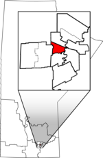
The West End is a mostly residential area of Downtown Winnipeg, Manitoba, Canada. It includes the neighbourhoods of Armstrong's Point, Colony, Daniel McIntyre, Minto, Sargent Park, Spence, St. Matthews, West Broadway, and Wolseley. The area is bordered by Route 62 (Osborne, Memorial, Colony, and Balmoral Streets) on the east, St. James Street on the west, the Assiniboine River on the south, and Notre Dame Avenue on the north.
Excerpt from the Wikipedia article West End, Winnipeg (License: CC BY-SA 3.0, Authors, Images).West End, Winnipeg
Banning Street, Winnipeg West End
Geographical coordinates (GPS) Address Nearby Places Show on map
 Continue reading on Wikipedia
 Geographical coordinates (GPS)
| Latitude | Longitude |
|---|---|
| N 49.894722222222 ° | E -97.172222222222 ° |
Address
Banning Street
Banning Street
R3G 0R1 Winnipeg, West End
Manitoba, Canada
Open on Google Maps