Roosevelt, Seattle

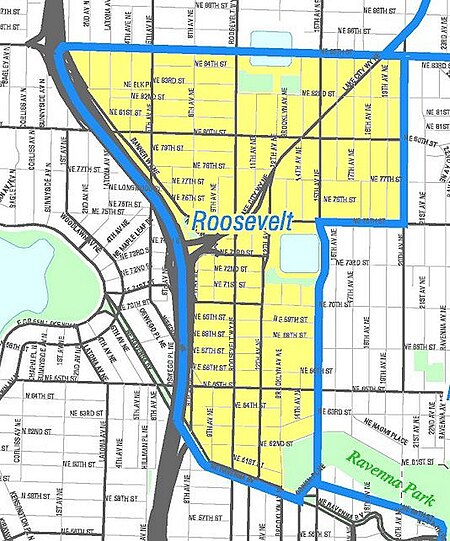
Roosevelt is a neighborhood in north Seattle, Washington. Its main thoroughfare, originally 10th Avenue, was renamed Roosevelt Way upon Theodore Roosevelt's death in 1919. The neighborhood received the name as the result of a Community Club contest held eight years later, in 1927.Roosevelt's principal and minor arterials are the one-way pair Roosevelt Way (southbound) and 12th Avenue NE (northbound), Lake City Way (SR 522) and 15th Avenue NE, and NE 65th and 75th Streets. City streets are laid out and designated in a pattern; see street layout of Seattle, directionals. The boundaries of the neighborhood are Interstate 5 to the west, beyond which lies Green Lake; NE Ravenna Boulevard and NE 60th Street to the south, beyond which is the University District; 15th Avenue NE to the east, beyond which is Ravenna; and Lake City Way (SR 522) to the north, beyond which lies Maple Leaf, (map).
Excerpt from the Wikipedia article Roosevelt, Seattle (License: CC BY-SA 3.0, Authors, Images).Roosevelt, Seattle
Northeast 68th Street, Seattle Green Lake
Geographical coordinates (GPS) Address Nearby Places Show on map
Geographical coordinates (GPS)
| Latitude | Longitude |
|---|---|
| N 47.678055555556 ° | E -122.31527777778 ° |
Address
Northeast 68th Street 1206
98115 Seattle, Green Lake
Washington, United States
Open on Google Maps


