place

Brother's Partnership
Houses in Howard County, MarylandHoward County, Maryland landmarks
Brother's Partnership

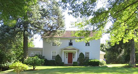
Brother's Partnership (also called Peter Harmon House) is a historic house in Ellicott City, Howard County, Maryland. The house is located on a 600-acre tract patented in 1734 by Joshua Dorsey named "Brother's Partnership". The house built on the property is a wooden structure with L shaped additions. James and Harriet Shipley sold the 66-acre property to Peter A. Harmon and the neighboring Curtis-Shipley Farmstead in 1874. In 1890 a kitchen addition was built onto the house. In 1927 a major restoration was completed. The property has been subdivided with no visible signs of the original farm. The house is surrounded by modern buildings in a residential cul-de-sac.

Excerpt from the Wikipedia article Brother's Partnership (License: CC BY-SA 3.0, Authors, Images).

Brother's Partnership
Brothers Partnership Court, Columbia Long Reach

Geographical coordinates (GPS) Address Nearby Places
placeShow on map

Wikipedia: Brother's PartnershipContinue reading on Wikipedia

Geographical coordinates (GPS)

Latitude Longitude
N 39.212777777778 ° E -76.803055555556 °
placeShow on map

Address

Brothers Partnership Court 5725
21045 Columbia, Long Reach
Maryland, United States
mapOpen on Google Maps

Brother's Partnership
Share experience

Nearby Places

Curtis-Shipley Farmstead

The Curtis—Shipley Farmstead is a historic home located at Ellicott City, Howard County, Maryland, United States. It is located on the first land grant in modern Howard County, then Anne Arundel County, to the English settler Adam Shipley in 1688 who settled properties in Maryland as early as 1675. The 500-acre estate was called "Adam the First". In 1874, the property was sold with buildings to Peter A. Harmon. A two-story Gothic Revival frame house built with an addition built by John and Lousia Curtis in 1891. Southeast of the main house is a gable-front frame garage, a one-story shed-roofed chicken house, a hog barn, a frame board-and-batten granary, and a board-and-batten bank barn with an unusually deep forebay. The property also contains Shipley and Brown family cemetery. William Smallwood in acquired the property and in 1883 the property was acquired by James A. Curtis, who willed it to his son Robert Curtis who in turn willed it his sons Robert Jr. and Glenn. In 1958 the existing porch was remodeled and converted into a full kitchen and indoor plumbing was added at that time. In 1992, the property boundaries were redefined by the Maryland State Highway Administration to accommodate the Route 100 construction through the historic farm. In 2002 56-acres was sold and subdivided to Buzzuto Homes for a development "Shipley's Grant" which surrounds the historic home now.The Curtis-Shipley Farmstead was listed on the National Register of Historic Places in 2006.

Spring Hill Farm (Ellicott City, Maryland)

The Spring Hill Farm is a historic slave plantation located in Ellicott City in Howard County, Maryland, United States. The site south of the Patapsco River produced Native American arrowheads in routine farming. The farm is part of a 1695 900 acre land patent named "Chews Resolution Manor". The property was a gift of Caleb Dorsey of Belmont to his daughter Rebecca and her husband Charles Ridgely creating the parcel "Rebecca's Lot". The main house was built about 1804. The property contains the Spring Hill quarters, a stone structure dating to 1790 built originally as a home for Edward Hill Dorsey. The structure has served as slave quarters, a carriage house with modern remodeling of the interior in the 1950s. The farm was later owned by the Clark family who also resided to the south at Fairfield Farm. Owner Garnett "Booker" Clark used the outbuildings to make and store whiskey during prohibition. Garnett's brother James "Booker" Clark maintained his credibility as a revenue officer by destroying the operation. About ten outbuildings of the farm are identified in 1790 tax rolls. By the 1970s the farm had been subdivided down to two parcels totaling 11 acres, with a large power-line easement and the New Cut Landfill facility occupying the northern tracts. In the year 2000, Glen Mar Church purchased 21 acres of the farmland from the Baugher family with an address of 4701 New Cut Road. In 2004 groundbreaking occurred and in 2008 the church relocated to the site from Glen Mar Road.