place

Mountjoy Farm

Houses in Howard County, MarylandHoward County, Maryland landmarks
Mountjoy Farm HO 145

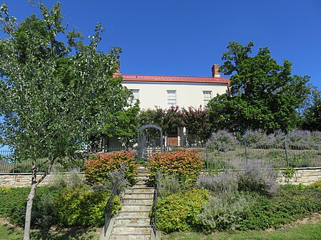
Mount Joy (sometimes called Santa Fe) is a historic slave plantation in Ellicott City, Howard County, Maryland, which has a current address of 5000 Executive Park Drive. The farm is located on the original land grant named Chews Resolution Manor. In 1810, Dr. Arthur Pue owned land around modern Route 100. Pue was the family doctor for the Gorman family, who Senator Arthur Pue Gorman is named after. The Pue family farmed the property with 19 slaves. In 1851, Samuel Wethered Jr. purchased 206 acres of farmland, creating "Santa Fe" from Dr. Pue. In 1912, 193 acres of the property was purchased by the Buck Family. On October 10, 1980, the estate was purchased by K&M Development Corporation (Brantly Development Group Corporation) for $532,000. In 2003, Winchester Homes purchased the site. The main farm building is an L-shaped layout built of brick with a stone foundation, built about 1851. In 2003 the remaining 86 acres of the site was subdivided and outbuilding were demolished for a Winchester Homes Subdivision, leaving the farmhouse remaining. A barn was offered to the Howard County Conservancy to relocate off the historic setting.

Excerpt from the Wikipedia article Mountjoy Farm (License: CC BY-SA 3.0, Authors, Images).

Mountjoy Farm
Executive Park Drive,

Geographical coordinates (GPS) Address Nearby Places
placeShow on map

Wikipedia: Mountjoy FarmContinue reading on Wikipedia

Geographical coordinates (GPS)

Latitude Longitude
N 39.237638888889 ° E -76.819166666667 °
placeShow on map

Address

Montjoy

Executive Park Drive 5000
21043
Maryland, United States
mapOpen on Google Maps

Mountjoy Farm HO 145
Share experience

Nearby Places

Woodlawn (Columbia, Maryland)

Woodlawn, is a historic slave plantation located at Columbia, Howard County, Maryland. It is a two-story, stuccoed stone house built in 1840 with wood frame portions constructed about 1785. It was part of a 200-acre farm divided from larger parcels patented by the Dorsey family. The design reflects the transition between the Greek Revival and Italianate architecture styles. The home is associated with Henry Howard Owings, a prominent Howard County landowner and farmer, who also served as a judge of the Orphan's Court for Howard County. Owings purchased the property in 1858 and died at Woodlawn in 1869. The former tobacco farm produced corn, oats, hay, and pork. The majority of the property surrounding Woodland and its slave quarters were subdivided by 1966 and purchased by Howard Research and Development for the planned community development Columbia, Maryland, leaving only 5 acres surrounded by multiple lots intended for development of an Oakland Ridge industrial center and equestrian center. The summer kitchen, smokehouse, corn crib and stable built about 1830 have been replaced by a parking lot.In 2003, Preservation Howard County appealed to the Columbia Association to restore the adjacent stone slave quarters building predating the 1789 Woodlawn house. In 2004 the property surrounding the Woodlawn manor was rezoned from residential to dense office use. All of the 200-year-old trees surrounding the property were declared diseased by the developer-owner and cut down. In June 2006, Developer Ron Brasher submitted plans to build a 71,705sf office building adjacent to Woodlawn with a parking lot surrounding the building on all sides. The project was temporarily delayed due to lack of road access and requests for reduced setbacks. The planning and zoning director cited the developer's efforts to restore and lease the 5000sf mansion for office space or a "condo opportunity" as a way to preserve the manor recently rezoned by the department. In August 2007, the Columbia Association purchased the slave quarters property and approved another $125,000 (~$170,816 in 2022) for restoration with the construction of the office project pending.It was listed on the National Register of Historic Places in 1983.

Temora (Ellicott City, Maryland)

Temora, is a historic home located at Ellicott City, Howard County, Maryland. It is a T-shaped, two-story and cupola, Tuscan-style Victorian house of stuccoed tongue-and-groove boards. The house was built in 1857 after a design prepared by Norris G. Starkweather, a little-known but accomplished architect from Oxford, England, who also designed the First Presbyterian Church and Manse at West Madison Street and Park Avenue in the Mount Vernon-Belvedere neighborhood in Baltimore, Maryland, with his later more famous assistant - Edmund G. Lind. The house was built for Dr. Arthur Pue Jr. on land given from his grandmother Mary Dorsey Pue of Belmont Estate. The name of the estate Temora comes from the poems of OssianLaura Hanna and Mrs John Breckinridge lived in the property afterward. County Councilman and representative William S. Hanna was also raised at TemoraA portion of the estate served as a farm with a hay field. In 1980, developer Alan Borg purchased the property, performing a minor restoration. In 1984 Borg held a "Decorator's Showhouse" event with rooms redecorated for free by various decorators retaining some of the original period materials combined with outside furnishings and materials. In 1985, Borg attempted to convert the house into a 15-room inn and restaurant, but failed to approval for the increased activity on the lot in a residential neighborhood. The land has been subdivided with a LDS Church built in the former pasture.It was listed on the National Register of Historic Places in 1976.

Dorsey Hall
Dorsey Hall

Dorsey Hall is a historic home in Columbia, Maryland, United States. It is a six-by-one-bay, 2+1⁄2-story stucco structure with a gable roof covered with asphalt shingles. It is a well-preserved and detailed example of the vernacular dwellings of the early 19th century in Howard County and associated with the Dorsey family, one of the "first families" of the county.Dorsey Hall was built on Dorsey's Search, a parcel of land patented by Hon. John Dorsey of Hockley-in-the-hole (1645–1714) in Baltimore County (now Howard County), the brother of Edward Dorsey. The 479-acre (194 ha) property adjacent to the north branch of the Patuxent River was surveyed by Richard Beard in December 1684, and granted to Dorsey in March 1696. The surrounding residential neighborhood of Dorsey's Search was named after the original land grant. Judge Richard Ridgley owned the property which returned to the Dorsey family after his death and purchase by Caleb Dorsey. The farm operated with slave labor until the death of Caleb Dorsey in 1864. In 1963, owner Julius Mandel and Gudelsky Company attempted to rezone the site for high-rise apartments. The property was retitled to the Gudelsky-owned Contee Sand and Gravel Company. The 685-acre property was then purchased by The Rouse Company's shell corporation Columbia Industrial Development Corp. for redevelopment, which was halted in 1968 by residential opposition. The building underwent a renovation in 1979. The stone gristmill remains were still visible onsite at the time.The 5.4 acres (2.2 ha) of land surrounding Dorsey Hall that was acquired by The Rouse Company was resold to land developers Richard Talkin and Donald Reuwer for $785,000 in 2000. In July 2000, a $3.5 million, 32,000 square-foot office project broke ground. By 2001, the site of the estate was subdivided and reduced to 2 acres with a survey claiming no outbuildings were present unlike the neighboring Woodlawn Estate from the same period.Dorsey Hall now stands at the entrance to a business park (comprising mostly medical offices) at 5100 Dorsey Hall Drive, the architecture of which is compatible with the building. However, although it forms an imposing image, it has no signage or other identification and is not open to the public. The confusion is amplified by the adjacent business park at 5010 Dorsey Hall Drive, which bears a sign naming itself the "Dorsey Hall Business Park." Just north of Maryland Route 108, Dorsey Hall is technically at the southern edge of unincorporated Ellicott City, Maryland, rather than the northern edge of Columbia. It was listed on the National Register of Historic Places in 2001.

Spring Hill Farm (Ellicott City, Maryland)

The Spring Hill Farm is a historic slave plantation located in Ellicott City in Howard County, Maryland, United States. The site south of the Patapsco River produced Native American arrowheads in routine farming. The farm is part of a 1695 900 acre land patent named "Chews Resolution Manor". The property was a gift of Caleb Dorsey of Belmont to his daughter Rebecca and her husband Charles Ridgely creating the parcel "Rebecca's Lot". The main house was built about 1804. The property contains the Spring Hill quarters, a stone structure dating to 1790 built originally as a home for Edward Hill Dorsey. The structure has served as slave quarters, a carriage house with modern remodeling of the interior in the 1950s. The farm was later owned by the Clark family who also resided to the south at Fairfield Farm. Owner Garnett "Booker" Clark used the outbuildings to make and store whiskey during prohibition. Garnett's brother James "Booker" Clark maintained his credibility as a revenue officer by destroying the operation. About ten outbuildings of the farm are identified in 1790 tax rolls. By the 1970s the farm had been subdivided down to two parcels totaling 11 acres, with a large power-line easement and the New Cut Landfill facility occupying the northern tracts. In the year 2000, Glen Mar Church purchased 21 acres of the farmland from the Baugher family with an address of 4701 New Cut Road. In 2004 groundbreaking occurred and in 2008 the church relocated to the site from Glen Mar Road.