Baslow
Derbyshire DalesOpenDomesdayTowns and villages of the Peak DistrictVillages in Derbyshire

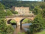
Baslow is a village in Derbyshire, England, in the Peak District, situated between Sheffield and Bakewell, just over 1 mile (1.6 km) north of Chatsworth House. It is sited by the River Derwent, which is spanned by a 17th-century bridge, alongside which is a contemporary toll house. Baslow village is composed of several distinct areas: Bubnell, Bridge End, Over End and Nether End. The village's civil parish is called Baslow and Bubnell, which in the 2011 census had a population of 1,178.
Excerpt from the Wikipedia article Baslow (License: CC BY-SA 3.0, Authors, Images).Baslow
Friedensstraße,
Geographical coordinates (GPS) Address Nearby Places Show on map
Geographical coordinates (GPS)
| Latitude | Longitude |
|---|---|
| N 53.248 ° | E -1.623 ° |
Address
Schloss Neugattersleben
Friedensstraße 1
06429 (Neugattersleben)
Sachsen-Anhalt, Deutschland
Open on Google Maps


