Chemnitz-Kaßberg
Chemnitz

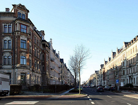
Kaßberg is the most densely populated neighbourhood within the German city of Chemnitz (the third largest city in the state of Saxony) and belongs to the largest Gründerzeit and Art Nouveau neighbourhoods in Germany. It is near the Chemnitz River and is to the west of the Chemnitz city centre. Its highest point is about 30 metres above the level of the city centre.
Excerpt from the Wikipedia article Chemnitz-Kaßberg (License: CC BY-SA 3.0, Authors, Images).Chemnitz-Kaßberg
Andréstraße, Chemnitz Kaßberg
Geographical coordinates (GPS) Address Nearby Places Show on map
Geographical coordinates (GPS)
| Latitude | Longitude |
|---|---|
| N 50.8333 ° | E 12.9028 ° |
Address
Andréstraße 31
09112 Chemnitz, Kaßberg
Saxony, Germany
Open on Google Maps


