City of Manningham

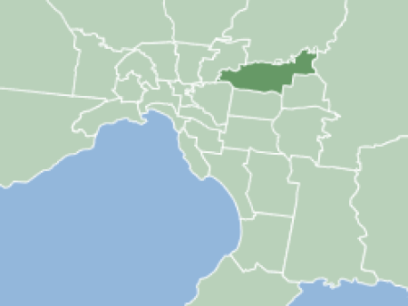
The City of Manningham is a local government area in Victoria, Australia in the north-eastern suburbs of Melbourne and is divided into 12 suburbs, with the largest being Doncaster and Doncaster East. It comprises an area of 113 square kilometres and had a population of 125,508 in June 2018.The district spans a roughly east–west direction along the southern banks of the Yarra River and across the undulating valleys of the Koonung, Ruffey and Mullum Mullum Creeks, alternating from typical low density suburban housing in the west to remnant bushland, within a green wedge, in the east. As such, the district encompasses the transition between the built and natural environments in Melbourne's east and promotes itself as a "balance of city and country".Formerly the City of Doncaster & Templestowe, the district is situated in the Wurundjeri nation's territory. Most of the first European settlers to the area were orchardists, arriving through the 1850s. Gold was first discovered in Victoria around the same time at Andersons Creek, in Warrandyte, however, the district saw varied growth as periods of low density suburban development occurred sporadically throughout the mid-late 20th century.
Excerpt from the Wikipedia article City of Manningham (License: CC BY-SA 3.0, Authors, Images).City of Manningham
Tindals Road, Melbourne Warrandyte
Geographical coordinates (GPS) Address Nearby Places Show on map
Geographical coordinates (GPS)
| Latitude | Longitude |
|---|---|
| N -37.766666666667 ° | E 145.2 ° |
Address
Tindals Road
Tindals Road
3111 Melbourne, Warrandyte
Victoria, Australia
Open on Google Maps


