place

Welkenraedt railway station

1843 establishments in BelgiumRailway stations in BelgiumRailway stations in Belgium opened in 1843Railway stations in Liège ProvinceWelkenraedt
Welkenrathbf3
Welkenrathbf3

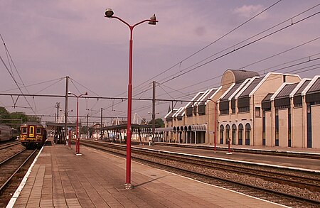
Welkenraedt is a railway station in the town of Welkenraedt, Liège, Belgium. The station opened on 24 October 1843 and is located on the 37, 39 and 49. The train services are operated by National Railway Company of Belgium (NMBS).

Excerpt from the Wikipedia article Welkenraedt railway station (License: CC BY-SA 3.0, Authors, Images).

Welkenraedt railway station
Boulevard Hector Grosjean,

Geographical coordinates (GPS) Address Nearby Places
placeShow on map

Wikipedia: Welkenraedt railway stationContinue reading on Wikipedia

Geographical coordinates (GPS)

Latitude Longitude
N 50.659166666667 ° E 5.9755555555556 °
placeShow on map

Address

Welkenraedt

Boulevard Hector Grosjean
4840
Liège, Belgium
mapOpen on Google Maps

Welkenrathbf3
Welkenrathbf3
Share experience

Nearby Places

Kelmis
Kelmis

Kelmis (German pronunciation: [ˈkɛlmɪs]; French: La Calamine, French pronunciation: ​[la kalamin]) is a municipality located in the Belgian province of Liège, named for the historical deposits of calamine (zinc ore) nearby. As of 2011, the population was 10,881; the area is 18.1 square kilometres (7.0 sq mi) and the population density is 601.2 inhabitants per square kilometre (1,557/sq mi).The municipality consists of the following sub-municipalities: Kelmis proper, Hergenrath, and Neu-Moresnet. The territory around the Vieille Montagne zinc mine in Kelmis was Neutral Moresnet, a neutral condominium of the Netherlands and Prussia (later Belgium and Germany) from 1816 to 1919, with the Mayor of Kelmis nominated by two commissioners from the neighbouring countries. Although there were attempts by locals at making it evolve into a fully independent microstate, all of them were thwarted and it remained under double-sovereignty and neutrality until its eventual annexation by Belgium after the First World War. There is a war memorial to German soldiers from Kelmis who were killed during the Franco-Prussian War, located in the Aachener Strasse, and one to inhabitants of Kelmis who were killed in the First and Second World Wars, located in the Kirchplatz (French: Place de l'Église).A small museum in Kelmis, the Museum Vieille Montagne, includes exhibits on Neutral Moresnet. Of the 60 border markers for the territory, more than 50 are still standing.In the nineteenth century a Low Dietsch dialect was spoken in Kelmis. Today Kelmis is German-speaking. It has facilities for French speakers and is one of the nine municipalities of the German‑speaking Community of Belgium.

Duchy of Limburg
Duchy of Limburg

The Duchy of Limburg or Limbourg was an imperial estate of the Holy Roman Empire. Much of the area of the duchy is today located within Liège Province of Belgium, with a small portion in the municipality of Voeren, an exclave of the neighbouring Limburg Province. Its chief town was Limbourg-sur-Vesdre, in today's Liège Province. The Duchy evolved from a county which was first assembled under the lordship of a junior member of the House of Ardenne–Luxembourg, Frederick. He and his successors built and apparently named the fortified town which the county, and later the Duchy, were named after. Despite being a younger son, Frederick had a successful career and also became Duke of Lower Lotharingia in 1046. Lordship of this county was not originally automatically linked with possession of a ducal title (Herzog in German, Hertog in Dutch), and the same title also eventually contested by counts of Brabant, leading to the invention of two new Ducal titles: Brabant and Limbourg. The extinction of the line of Frederick's grandson Henry in 1283 sparked the War of the Limburg Succession, whereafter Limburg was ruled by the Dukes of Brabant in personal union, eventually being grouped together with the Brabantian "Overmaas" territories bordering it (including Dalhem, Valkenburg, and 's-Hertogenrade), to be one of the Seventeen Provinces of the Burgundian Netherlands. Unlike other parts of this province, the lands of the duchy stayed intact within the Southern Netherlands, under Habsburg control, after the divisions caused by the Eighty Years' War and the War of the Spanish Succession. However finally, after the failed Brabant Revolution in 1789, the duchy's history was terminated with the occupation by French Revolutionary troops in 1793. The easternmost lands were reunited within modern Belgium only after World War I. The duchy was multilingual, being the place where Dutch, French, and German dialects border upon each other and coexist at their geographical extremes, both now and in medieval times. Its northern and eastern borders are the approximate boundaries of the modern state of Belgium with the Netherlands and Germany, at their "tripoint". The eastern part, which includes Eupen, is the administrative capital and northernmost part of the modern German-speaking Community of Belgium. The Duchy also included the main part of the Pays de Herve, famous for its pungent-smelling soft cheese known as Limburger or Herve.