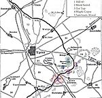
The Actions of St Eloi Craters from 27 March to 16 April 1916, were local operations in the Ypres Salient of Flanders, during the First World War by the German 4th Army and the British Second Army. Sint-Elooi (the French St Eloi is commonly used in English) is a village about 5 km (3.1 mi) south of Ypres in Belgium. The British dug six galleries under no man's land, placed large explosive charges under the German defences and blew them at 4:15 a.m. on 27 March. The 27th Division captured all but craters 4 and 5. The 46th Reserve Division counter-attacked but the British captured craters 4 and 5 on 30 March. The Canadian Corps took over, despite the disadvantage of relieving troops in action.
The Canadians inherited positions in a deplorable state, the British having pressed their advantage, rather than consolidating the captured ground. On the night of 5/6 April a German methodical attack (Gegenangriff) recovered the captured craters. Canadian runners struggled to deliver messages and for several days the Canadian and British staffs were ignorant of which craters had been captured, the topography having been changed so much by the mine detonations. There were 17 craters, the new ones superimposed on the old, the ground full of shell-holes and derelict trenches. Snipers made it impossible to orientate and fresh troops easily mistook one pair of craters for another.
The Canadians counter-attacked several times, then concentrated on consolidating the front line, ready for another attempt. Constant rain, oozing mud and incessant artillery-fire exhausted troops quickly and battalions had to be relieved after a couple of days. Canadian and British staffs were still ignorant of the German capture of craters 4 and 5. Conflicting reports added to the uncertainty but a reconnaissance by a Canadian major on 10 April found that the Germans were in crater 4. On 16 April, the Royal Flying Corps (RFC) photographed the area, showing the Germans in craters 2, 3, 4 and 5 and a trench round the front lips. Plans to attack were cancelled and for two weeks both sides exchanged artillery-fire.
The mud and poor weather caused unprecedented misery on the troops but the first attack showed that with preparation, surprise and good timing a limited objective could be captured. The British had attacked with tired troops and had not achieved all of their objectives and the second attempt was at the cost of quick consolidation. At St Eloi, against an attack on a narrow front, where the defender had good observation, the ground could not be held. It was an open question as to what width of front to attack, narrow enough to guarantee success, yet wide enough to force the Germans to disperse their artillery-fire so that captured ground could be held.


