place

Holmes railway station

Disused railway stations in RotherhamFormer Midland Railway stationsPages with no open date in Infobox stationRailway stations in Great Britain closed in 1955Railway stations in Great Britain opened in 1838
Use British English from March 2015
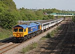
Holmes Station, Rotherham geograph.org.uk 1366901

Holmes railway station was a railway station in Rotherham, South Yorkshire, England. The station served the communities of Masbrough and Holmes and was situated on the former Sheffield and Rotherham Railway (S&R) line between Rotherham Westgate Station and Wincobank and Meadowhall Station. The station, which had two flanking platforms, opened with the line. With the building of the North Midland Railway through Rotherham Masborough, Holmes became the junction of the curve from this station to the Sheffield line. A second curve, allowing trains to travel from the Sheffield line to the North Midland facing south was opened in 1869.The station was closed in 1955. Nowadays a footbridge spans the two tracks almost above Holmes Junction which, via a British Rail - built chord line, known as "The Holmes Chord", now links the former S&R line to the former Great Central Railway line through Rotherham Central. The access line to Booth's scrapyard leaves the Holmes Chord shortly after the junction. This line was an original part of the S&R to Rotherham Westgate. Nearby was the factory of Isaac Dodds and Son who supplied the early locomotives for the S&R.

Excerpt from the Wikipedia article Holmes railway station (License: CC BY-SA 3.0, Authors, Images).

Holmes railway station

Geographical coordinates (GPS) Address Nearby Places
placeShow on map

Wikipedia: Holmes railway stationContinue reading on Wikipedia

Geographical coordinates (GPS)

Latitude Longitude
N 53.427416 ° E -1.37929 °
placeShow on map

Address


S61 1DF , Masbrough
England, United Kingdom
mapOpen on Google Maps

Holmes Station, Rotherham geograph.org.uk 1366901
Share experience

Nearby Places

Blackburn Meadows
Blackburn Meadows

Blackburn Meadows is an area of land just inside the Sheffield city border at Tinsley, England. It became the location of the main sewage treatment works for the city in 1884, and is now one of the largest treatment works in Britain. The treatment process was rudimentary, with sludge being removed to ponds and then to drying beds, after which it was used as manure or transferred by rail to a tip at Kilnhurst. The works progressively expanded to improve the quality of effluent discharged to the River Don and was a pioneer in the use of bio-aeration, following experiments by the works manager during the First World War. This process became known as the "Sheffield System", and was demonstrated to visitors from Great Britain and abroad. Despite these improvements, ammonia levels in the river below the works were high, and fish populations did not survive. The works had its own internal standard gauge railway for over 100 years, which used three steam and three diesel locomotives over the course of its existence, until its replacement by road vehicles in the 1990s. During the 1926 general strike, the locomotives hauled trains over the main line, delivering wagons to Kilnhurst tip under a special dispensation. By the 1960s, the Sheffield sewer system was inadequate for the volume of effluent produced, and the Don Valley Interceptor Sewer was tunnelled beneath the city to the works, enabling 26 storm sewage overflows into the river to be shut down. Water quality was further improved by a new treatment process installed in 1992 to reduce ammonia levels, enabling fish stocks to be re-established in the lower River Don. Subsequent improvements have been made so that the works complies with the Waste Incineration Directive and the Freshwater Fish Directive. The works was inundated by flood water on 25 June 2007, when the Don burst its banks, but was recommissioned in just 18 days. A power station was operational on the southern part of the site from 1921, supplying electricity to the steel works of the Lower Don Valley. Although it closed in October 1980, two of its cooling towers which were designed by L. G. Mouchel and Partners in 1937, remained until 2008, as demolition was difficult because of their proximity to Tinsley Viaduct, which carries the M1 motorway across the Don valley. Following extensive upgrading of the treatment works, to improve the quality of discharges to the river still further, the sludge beds became redundant, and have been turned into a nature reserve, providing habitat for migrating birds.