place

Westeinde, Drenthe

Drenthe geography stubsPopulated places in Drenthe
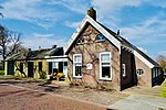
Exterieur overzicht voorzijde Westeinde 20322644 RCE

Westeinde is a hamlet in the Dutch province of Drenthe. It is part of the town Dwingeloo and of the municipality of Westerveld. The name Westeinde means 'western end' and alludes to the fact that it lies west of Dwingeloo. Westeinde lies about 14 km northwest of Hoogeveen. The statistical area "Westeinde", which also includes the surrounding countryside, consists of around 50 villas and large estates and has a population of around 130.Westeinde is characterized by the presence of one of the four Havezates (a large manor reserved for the nobility) that were built in or near Dwingeloo, namely Oldengaerde. The estate dates back to the first half of the 15th century. In 1808, the estate was purchased by Jonkheer Aalt Willem van Holthe, who was the mayor of Dwingeloo from 1812 to 1852. Oldengaerde has remained in his family ever since, and his descendants have decorated the Westeinde with villas such as De Bork (1910), Olden Hut (1916), Nije Batinghe (1923, named after another Havezathe 'Batinghe') and Nyengaerde (1926, named after Oldengaerde).

Excerpt from the Wikipedia article Westeinde, Drenthe (License: CC BY-SA 3.0, Authors, Images).

Westeinde, Drenthe
Westeinde, Westerveld

Geographical coordinates (GPS) Address Nearby Places
placeShow on map

Wikipedia: Westeinde, DrentheContinue reading on Wikipedia

Geographical coordinates (GPS)

Latitude Longitude
N 52.825 ° E 6.3491666666667 °
placeShow on map

Address

Westeinde 43a
7991 RT Westerveld
Drenthe, Netherlands
mapOpen on Google Maps

Exterieur overzicht voorzijde Westeinde 20322644 RCE
Share experience

Nearby Places

Dwingeloo Radio Observatory

The Dwingeloo Radio Observatory is a single-dish radio telescope near the village of Dwingeloo (Dutch pronunciation: [ˈdʋɪŋəloː]) in the northeastern Netherlands. Construction started in 1954, and the telescope was completed in 1956. The radio telescope has a diameter of 25 m. At the time of completion it was the largest radio telescope in the world, but it was overtaken in 1957 by the 250 foot (76 m) Lovell Telescope. As of 2000, it was no longer in operation in an official capacity. Since August 2009, the radio telescope has been a national heritage site (rijksmonument). The telescope dish was removed for restoration in June 2012. The "C.A. Muller Radio Astronomy Station" foundation ("CAMRAS" for short) restored the telescope to working order. The dish was remounted in November 2012.Radio amateurs along with amateur and professional astronomers, use the telescope for projects, one being Earth–Moon–Earth communication, also known as moonbounce, which allows for people on different parts of Earth to communicate via the Moon. In this technique, radio wave signals are aimed at the Moon by one location, bounce off the Moon's surface, and are detected by an antenna at a different location on Earth. "Visual Moonbounce" is a technology to moonbounce images at amateur-radio frequencies. It is based on artistic research with the Dwingeloo Radiotelescoop by artist Daniela De Paulis as part of her project "OPTICKS" The radio telescope is owned by ASTRON, the Netherlands Institute for Radio Astronomy. The site of the Dwingeloo Radio Observatory also houses most of the staff of ASTRON and a test site for the Low Frequency Array radio telescope, LOFAR. Two galaxies are named after this telescope: Dwingeloo 1 and Dwingeloo 2.