place

RAF Yatesbury

Defunct airports in EnglandRoyal Air Force stations in WiltshireRoyal Air Force stations of World War II in the United KingdomRoyal Air Force stations of World War I in the United KingdomUse British English from October 2017
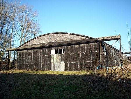
Hangar, RAF Yatesbury geograph.org.uk 4282603

RAF Yatesbury is a former Royal Air Force airfield near the village of Yatesbury, Wiltshire, England, about 4 miles (6 km) east of the town of Calne. It was an important training establishment in the First and Second World Wars, and until its closure in 1965. For a time in the 1950s, part of the site became RAF Cherhill.

Excerpt from the Wikipedia article RAF Yatesbury (License: CC BY-SA 3.0, Authors, Images).

RAF Yatesbury
Juggler's Lane,

Geographical coordinates (GPS) Address Nearby Places
placeShow on map

Wikipedia: RAF YatesburyContinue reading on Wikipedia

Geographical coordinates (GPS)

Latitude Longitude
N 51.436944444444 ° E -1.9238888888889 °
placeShow on map

Address

Juggler's Lane 1
SN11 8YA , Cherhill
England, United Kingdom
mapOpen on Google Maps

Hangar, RAF Yatesbury geograph.org.uk 4282603
Share experience

Nearby Places

Calstone and Cherhill Downs

Calstone and Cherhill Downs (grid reference SU047692) is a 128.6 hectare biological Site of Special Scientific Interest in Wiltshire, notified in 1971, including downland at Calstone Wellington and Cherhill. It provides one of the best examples in Wiltshire of unimproved downland.The site forms part of the North Wessex Downs Area of Outstanding Natural Beauty. The site lies towards the western edge of the Marlborough Downs, has a narrow plateau of the Middle and Upper Chalk and descends steeply to the north and more gently to the south. The south-facing slope has a complex structure of narrow, steep-sided dry valleys and coombes and has a mixture of grasses, sedges and forbs. Here grow a typical calcareous community including glaucus sedge, sheep’s-fescue, meadow oat-grass, heath-grass and common quaking-grass, together with cowslip, salad burnet, rock-rose, betony, field fleawort, bastard-toadflax, round-headed rampion, small scabious, devil’s-bit scabious, horseshoe vetch, kidney vetch and chalk milkwort. Orchids found here include, early purple orchid, burnt orchid, fragrant orchid, bee orchid and frog orchid, the last three all being common here.The site is also excellent for invertebrates, hosting the small blue, chalkhill blue, Duke of Burgundy and marsh fritillary, as well as the rare wart-biter bush cricket and the uncommon bug Sehirus dubius The lime-loving heath snail Helicella itala is also found here. There is a dewpond that holds water all year round; newts are found here as well as the Emperor dragonfly and the azure damselfly Coenagrion puella.

Calstone
Calstone

Calstone is a former tithing and manor in Wiltshire, England, lying southeast of Calne and adjacent to Calstone Wellington. The area was almost certainly part of the large Calne estate held by the king in the 10th century or earlier. By 1066, three estates had been granted away: one which became Calstone manor, another which became Calstone Wellington manor, and a third which was later called Blunt's. The Domesday survey in 1086 recorded three landholdings at Calestone, with altogether 62 households and four mills. The remainder, later called the 'black land' of Calstone, was kept by the Crown until 1194 when it was granted to a new owner and became the manor and parish of Blackland.Calstone village was divided between Calne and Calstone Wellington parishes. A church had been built at Calstone by 1301, presumably on the Blunt's estate; from 1600 the ecclesiastical parish was called Calstone Wellington, and the village later took this name also. Since at least 1889, the name Calstone has not been used for the settlement on Ordnance Survey maps.The Wiltshire Victoria County History lists the landowners, including the Barons Zouche from the early 14th century to the 1550s, and from 1572 Sir Lionel Duckett (1511–1587). He was a wealthy London merchant, Lord Mayor of London in 1572–1573, who supported early voyages to Africa which paved the way for the slave trade in later centuries. His son Stephen and seven other Duckett descendants were returned as MP for the rotten borough of Calne, the small number of electors being under the influence of the lord of the manor. In 1763, Thomas Duckett sold much land, including Calstone, to William Petty, 2nd Earl of Shelburne (from 1784 Marquess of Lansdowne and Viscount Calne and Calston). These lands remained part of the family's Bowood landholdings until 1954, when the Marquesses began to sell off farms, while retaining some property in the area.An estate later called Calstone Wylye was detached from Calstone manor in the 12th century, and reunited with Calstone when it was bought by Stephen Duckett in 1585.In the 19th century, Calstone Wellington was recognised as civil parish, while Calstone remained a tithing of Calne. In 1890, both Calstone Wellington and Calstone were absorbed into the newly created Calne Without parish. For the history of the church and its parish, see Calstone Wellington.