place

Orange County, California
1889 establishments in CaliforniaCalifornia countiesCounties in Southern CaliforniaGovernment units that have filed for Chapter 9 bankruptcyGreater Los Angeles
Los Angeles metropolitan areaMajority-minority counties in CaliforniaOrange County, CaliforniaPopulated places established in 1889Use mdy dates from February 2022
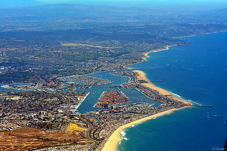
The City of Newport Beach July 2014 photo D Ramey Logan

Orange County is located in the Los Angeles metropolitan area in Southern California. As of the 2020 census, the population was 3,186,989, making it the third-most populous county in California, the sixth most populous in the U.S., and more populous than 21 U.S. states. Although largely suburban, it is the second most densely populated county in the state, behind San Francisco County. The county's three most populous cities are Anaheim, Santa Ana, and Irvine, each of which has a population exceeding 300,000. Santa Ana is also the county seat. Six cities in Orange County are on the Pacific coast, including Seal Beach, Huntington Beach, Newport Beach, Laguna Beach, Dana Point, and San Clemente. Orange County is included in the Los Angeles-Long Beach-Anaheim Metropolitan Statistical Area. The county has 34 incorporated cities. Older cities like Santa Ana, Anaheim, Orange, and Fullerton have traditional downtowns dating back to the 19th century, while newer commercial development or "edge cities" stretch along I-5 between Disneyland and Santa Ana and between South Coast Plaza and the Irvine Business Complex, and cluster at Irvine Spectrum. Although single-family homes make up the dominant landscape for most of the county, Northern and Central Orange County is relatively more urbanized and dense as compared to those areas beyond Irvine, which are less dense, though still contiguous and primarily suburban rather than exurban. The county is a tourist center, with attractions like Disneyland, Knott's Berry Farm, Mission San Juan Capistrano, Modjeska House, Segerstrom Center for the Arts, Yost Theater, Bowers Museum, Balboa Island, Angel Stadium, Downtown Santa Ana, the Honda Center, and several popular beaches along its more than 40 miles (64 km) of coastline. It is also home to a major research university, the University of California, Irvine (UCI), along with a number of other notable colleges and universities such as Chapman University and Cal State Fullerton.

Excerpt from the Wikipedia article Orange County, California (License: CC BY-SA 3.0, Authors, Images).

Orange County, California
San Diego Creek Trail, Irvine Oak Creek

Geographical coordinates (GPS) Address Nearby Places
placeShow on map

Wikipedia: Orange County, CaliforniaContinue reading on Wikipedia

Geographical coordinates (GPS)

Latitude Longitude
N 33.67 ° E -117.78 °
placeShow on map

Address

San Diego Creek Trail

San Diego Creek Trail
92604 Irvine, Oak Creek
California, United States
mapOpen on Google Maps

The City of Newport Beach July 2014 photo D Ramey Logan
Share experience

Nearby Places

Old Town Irvine
Old Town Irvine

Old Town Irvine was designated a California Historic Landmark (No.1004) on November 11, 1991. Old Town Irvine is in the city of Irvine, California in Orange County A Historic marker is at 14980 Sand Canyon Avenue, Irvine. The marker is to remember the founding the City of Town Irvine in 1887. The town of Irvine started as a train stop for the Santa Fe Railroad in 1889, where barley warehouse was built. At the time of founding the town was called Myford, California. Myford was the youngest son of James H. Irvine, who the town would be renamed after. James Irvine called the new town Myford, as at the time there was a City of Irvine in Calaveras County in Northern California. Myford was renamed Irvine in 1914, as the Northern California town changed its name to Carson Hill. The 125,000-acre Irvine Ranch was the largest employer in the town for years, a very busy place during harvest time. The town had a school, general store, blacksmith shop, diner, and a hotel for seasonal workers, all around Central Avenue and the train station. The Ranch lost its place as the center of town in the 1960s, with the housing boom and a new town center was built up. Irvine incorporated as a city in 1971. The old portions of Irvine, renamed East Irvine, had become run down. Much of the old Ranch in East Irvine was abandoned or taken down. Central Avenue was renamed Sand Canyon Ave, which became a main highway. The 1980 plan to make Sand Canyon Ave wider threaten some of the Historic Landmarks in Irvine. A Historic Preservation Committee was formed and the town worked to save Old Town Irvine. The City of Irvine working with the Sand Canyon Historical Partners and the Irvine Historical Society, they came up with a plan to reuse some of the old buildings.

Agua Chinon Creek

Agua Chinon Creek or Agua Chinon Wash is an urban stream in the city of Irvine, Orange County, California. The creek flows southwest from its headwaters in the foothills of the Santa Ana Mountains for about 8 miles (13 km) to join San Diego Creek near the Verizon Amphitheatre. The creek drains a total watershed area of 7,049 acres (2,853 ha).The headwaters of the creek consist of approximately 1,200 acres (490 ha) of undeveloped canyonlands in the Limestone Canyon Nature Preserve. The area includes the badlands known as The Sinks, which are nicknamed "the Grand Canyon of Orange County" due to its sheer cliffs. At the bottom of the canyons Agua Chinon Creek flows under State Route 241 and is impounded by the Agua Chinon Debris Dam, which provides flood control to the valley below. Completed in 1998, the dam has a capacity of 256 acre-feet (316,000 m3) of water.The middle section of Agua Chinon Creek flows through a culvert underneath the former El Toro Marine Corps Air Station. The redevelopment of the air base as Orange County Great Park includes plans to daylight the creek and restore streambank habitat. This work is proposed to create a wildlife corridor between the Cleveland National Forest and the Laguna Coast wilderness area (Crystal Cove State Park).Below the Air Base/Great Park the creek continues in a buried channel under the BNSF Railway tracks, Interstate 5 and the Irvine Spectrum Center, and is joined from the left by its main tributary, Borrego Canyon Wash. It emerges as an open channel just a few hundred feet before its confluence with San Diego Creek. The confluence is situated just north of the Interstate 405 near the 405/133 interchange.