place

Idsal

Islands of RogalandRogaland geography stubsStrand, Norway
Norway Idsal
Norway Idsal

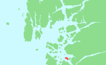
Idsal is an island in Strand municipality in Rogaland county, Norway. The 3.1-square-kilometre (1.2 sq mi) island lies directly between the island of Idse and the mainland with the Idsefjorden and the Høgsfjorden on either side of the island. There are short bridge on the east and west sides of Idsal that connect it to the mainland and to Idse, respectively. Most of the island's 12 permanent residents live on the southwestern side of the island, however there are many holiday cottages located all over the island.

Excerpt from the Wikipedia article Idsal (License: CC BY-SA 3.0, Authors, Images).

Geographical coordinates (GPS)

Latitude Longitude
N 58.9872 ° E 5.9822 °
placeShow on map

Address

Idsal

Idsal
4102 Strand
Norway
mapOpen on Google Maps

Norway Idsal
Norway Idsal
Share experience

Nearby Places

Jørpeland
Jørpeland

Jørpeland is the administrative centre of Strand municipality in Rogaland county, Norway. The town is located on the western coast of the mainland, along the shore of the Idsefjorden, about 20 kilometres (12 mi) northeast of the city of Stavanger. It sits along the Norwegian National Road 13 a short distance southeast of the village of Tau where the Ryfast tunnel has its eastern entrance. The name "Jørpeland" is composed of the slightly changed Old Norse word "jarpr", which translates to brown, and the word land ("brownland"). The reason for this name is that historically, the river Jørpelandsånå used to turn brown during times of flood.The 4.09-square-kilometre (1,010-acre) town has a population (2019) of 7,230 and a population density of 1,768 inhabitants per square kilometre (4,580/sq mi). Jørpeland is also known as "Pulpit Rock City", because Jørpeland is nearest city to the Preikestolen, which attracts tourists from all over the world. The Preikestolen is a huge cliff overlooking the Lysefjorden and it sits about 10 kilometres (6.2 mi) southeast of Jørpeland. Jørpeland became designated as a town by the municipal council on 1 April 1998. Prior to that time it was simply considered a very large village. Jørpeland is divided into nine boroughs: Leite, Barka, Tungland, Barkved, Jøssang, Førland, Langeland, Grønnevoll, and Fjelde. The river Jørpelandsåna runs through the town before emptying into the fjord on the south side of the town.

Strand, Norway
Strand, Norway

Strand is a municipality in Rogaland county, Norway. It is located in the traditional district of Ryfylke. The administrative centre of the municipality is the town of Jørpeland. The municipality lies across the fjord from the city of Stavanger. The Ryfast tunnel system connects Stavanger and Strand by a very long undersea tunnel. The villages of Sørskår and Fiskå are located in northern Strand, on the southern shore of the Årdalsfjorden. This area of Strand produces fruit, vegetables, and dairy products. The Fiskå Mølle (Fiskå Mill) is located in Fiskå. The larger village of Tau is located on the western coast of Strand. It is a transportation hub with ferry connections to the city of Stavanger and bus services to nearby Hjelmelandsvågen and deeper into the Ryfylke district. About 10 kilometres (6.2 mi) southeast of Tau is the municipal center of Jørpeland. This town is the largest settlement in Strand with about 7,000 people. The 262-square-kilometre (101 sq mi) municipality is the 278th largest by area out of the 356 municipalities in Norway. Strand is the 90th most populous municipality in Norway with a population of 13,474. The municipality's population density is 57.2 inhabitants per square kilometre (148/sq mi) and its population has increased by 13.4% over the previous 10-year period.The cross-country and marathon mountain biker Gunn-Rita Dahle comes from Bjørheimsbygd. She has won a gold medal in the Summer Olympics 2004, in Athens. Holtaheia was the mountain behind Holta farm where 34 school boys, 2 teachers and 3 crew died, when the Cunard Viking flight 'Papa Mike' crashed into the mountain, en route to Stavanger.