Curepipe
CurepipeMoka DistrictPages with Mauritian Creole IPAPlaines Wilhems District
.jpg)
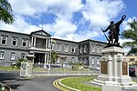
Curepipe (Mauritian Creole pronunciation: [kiːəpip]) also known as La Ville-Lumière (The City of Light), is a town in Mauritius, located mainly in the Plaines Wilhems District. Its eastern part lies in the Moka District. The town is administered by the Municipal Council of Curepipe. Curepipe lies at a higher elevation, often referred to as the "Central Plateau". According to the census made by Statistics Mauritius in 2018, the population of the town was at 78,618.
Excerpt from the Wikipedia article Curepipe (License: CC BY-SA 3.0, Authors, Images).Curepipe
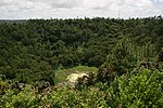
Footpath around the lakepoint, Vacoas-Phoenix La Vigie
Geographical coordinates (GPS) Address Nearby Places Show on map
 Continue reading on Wikipedia
 Geographical coordinates (GPS)
| Latitude | Longitude |
|---|---|
| N -20.318775 ° | E 57.526294444444 ° |
Address
City House Curepipe
Footpath around the lakepoint
74513 Vacoas-Phoenix, La Vigie
Plaines Wilhems, Mauritius
Open on Google Maps