Central Park (Burnaby)

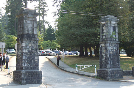
Central Park is a 90-hectare (220-acre) urban park in Burnaby, British Columbia, founded in 1891.The park is on the Vancouver–Burnaby border, just west of the Metropolis at Metrotown shopping complex, and is bounded by Boundary Road on the west, Kingsway on the north, Patterson and Willingdon Avenues on the east, and Imperial Road on the south. The nearest SkyTrain station, Patterson station, named for Burnaby pioneer Dugald Campbell Patterson, is at the park's northeast corner. The main entrance to Central Park is off Kingsway near Patterson Avenue. Central Park was once a naval reserve set aside as a source of masts and spars for ships of the Royal Navy. The park was named to honour Mrs. Sarah (Christine) Oppenheimer, the wife of Vancouver's second mayor, who was born in New York City.Central Park's primary attraction is the large proportion of its land reserved as a well-preserved temperate rainforest ecosystem, with numerous walking trails. Among its other attractions are the award-winning children's playground, pitch and putt golf, an outdoor swimming facility, a lawn bowling facility, several picnic areas, tennis courts, and a couple of small duck ponds. Wildlife in the park includes grey squirrels and coyotes. A fitness circuit was installed during the time period between 2012 and 2014 in the park replacing the old wooden exercise apparatus to metal and rubber ones. These apparatus are situated throughout the park and include an exercise bike, pull-up bars, and weights. The 12 stations are designed to improve strength, cardiovascular health, balance, and flexibility. A total of 13,998 pounds (6,349 kg) of rubber was used in the manufacturing of the apparatus. The creation of the circuit was sponsored by Tire Stewardship BC and Kal Tire. The Korean War Memorial is in the west side of the park, close to Boundary Road. Swangard Stadium, another Burnaby landmark and a former home for the Vancouver Whitecaps soccer team, is located at the northwest corner of Central Park.
Excerpt from the Wikipedia article Central Park (Burnaby) (License: CC BY-SA 3.0, Authors, Images).Central Park (Burnaby)
Trail of Hope, Burnaby
Geographical coordinates (GPS) Address Nearby Places Show on map
Geographical coordinates (GPS)
| Latitude | Longitude |
|---|---|
| N 49.227071 ° | E -123.018208 ° |
Address
Trail of Hope
V5H 1Y4 Burnaby
British Columbia, Canada
Open on Google Maps


