place

Union Wesley Methodist Episcopal Church Complex

19th-century Methodist church buildings in the United StatesAfrican-American history of DelawareCamp meeting groundsCampgrounds in the United StatesChurches completed in 1873
Churches in Sussex County, DelawareChurches on the National Register of Historic Places in DelawareDelaware Registered Historic Place stubsDelaware building and structure stubsMethodist churches in DelawareNational Register of Historic Places in Sussex County, DelawareSouthern United States church stubsUse mdy dates from August 2023
Union Wesley United Methodist Church

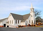
The Union Wesley Methodist Episcopal Church Complex is a historic church and summer camp meeting facility on Powell Farm Road near Clarksville, Delaware. The property was developed in the post-Civil War era as a summer religious camp for African Americans. It was established around 1873, with an open tabernacle structure for religious functions, surrounded by modest cottages. An 1890 one-room schoolhouse that was used in the education of African-American children was adapted as the camp's refectory in 1922, and in 1959 the Union Wesley Methodist Episcopal Church was built on the property. The school building in particular is notable as one of the best-preserved late 19th-century schools for African-Americans in the state.The complex was listed on the National Register of Historic Places in 2014.

Excerpt from the Wikipedia article Union Wesley Methodist Episcopal Church Complex (License: CC BY-SA 3.0, Authors, Images).

Union Wesley Methodist Episcopal Church Complex
Powell Farm Road,

Geographical coordinates (GPS) Address Nearby Places
placeShow on map

Wikipedia: Union Wesley Methodist Episcopal Church ComplexContinue reading on Wikipedia

Geographical coordinates (GPS)

Latitude Longitude
N 38.545 ° E -75.146944444444 °
placeShow on map

Address

Powell Farm Road 32101
19945
Delaware, United States
mapOpen on Google Maps

Union Wesley United Methodist Church
Share experience

Nearby Places

Blackwater Presbyterian Church

Blackwater Presbyterian Church was a historic Presbyterian church building located near Clarksville, Sussex County, Delaware. It was built in 1767 and rebuilt in 1893. It was a small, frame chapel sheathed in clapboard and measuring 35 feet by 30 feet. It featured a portico supported by a Victorian style bracket. It was the oldest Presbyterian church building in Southern Delaware. The congregation was abolished in October 1921.It was added to the National Register of Historic Places in 1976. In the 1970s the church was restored by the Colonel Armwell Long Chapter the Daughters of the American Revolution. In May 2018 the church, which was structurally unsound, was demolished. According to official state sources: Many of the early settlers of this region, then a part of Maryland, were Presbyterians who had been denied their freedom of worship. For many years local Presbyterians were forced to travel a great distance to the nearest church. In 1763, a congregation was organized in this area by Reverend Charles Tennent, the charismatic son of William Tennent, founder of Princeton University. Services were held in the homes of members until 1767 when the present Blackwater Presbyterian Church was constructed. Over time the travel conditions faced by many members resulted in the formation of separate churches in the growing communities of Ocean View and Frankford. By the late 19th century regular services at Blackwater had been discontinued. Occasional meetings were held until 1921, when the church organization was formally abolished. Since 1949 the property has been managed by a Trust established by the Tunnell family, who have been active supporters of the church since its founding.

Indian River (Delaware)

The Indian River is a river and estuary, approximately 15 mi (24 km) long, in Sussex County in southern Delaware in the United States. The river is named after a Native American reservation that was located on its upper reaches. The Indian River rises approximately 2 miles (3.2 km) southwest of Georgetown and flows east, past Millsboro, its head of navigation. It enters Indian River Bay, an inlet of the Atlantic Ocean south of Cape Henlopen. The lower 6 miles (9.7 km) of the river form a navigable tidal estuary stretching westward from Indian River Bay, which is protected from the open ocean by two sand bar peninsulas. East of the bay is its mouth, the Indian River Inlet. Until 1928, the Indian River Inlet was a natural waterway that shifted up and down a two-mile (3.2 km) stretch of the coast. Dredging kept the inlet open in its current location between 1928 and 1937, and in 1938 the United States Army Corps of Engineers built jetties that hold it in place. Roads cross the river in three places, at U.S. Route 113 (in Millsboro), Delaware Route 24/Delaware Route 30 (also in Millsboro), and Delaware Route 1 (at Indian River Inlet in the Delaware Seashore State Park). With the Indian River Inlet in a fixed place beginning in 1928, it became possible to build a bridge to span it, and the completion of the Ocean Highway (present-day Delaware Route 1 and now known as Coastal Highway) between Rehoboth Beach and Bethany Beach in 1933 prompted Delaware to build a span to connect the northern and southern segments of the highway. Since 1934, six bridges have spanned the inlet, all known informally as the Indian River Inlet Bridge, although all but the first officially were named the Charles W. Cullen Bridge. The current Indian River Inlet Bridge opened in 2012.