Hung Fa Chai
Closed AreaHong Kong geography stubsMountains, peaks and hills of Hong KongSha Tau Kok

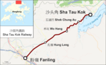
Hung Fa Chai (Chinese: 紅花寨) is a hill in the New Territories of Hong Kong. With a height of 489 metres (1,604 ft), it lies 500 metres (1,600 ft) to the northeast of Robin's Nest, just inside the Frontier Closed Area south of the border with Shenzhen in mainland China. On old Colonial maps of Hong Kong, it was marked as Ben Nevis, after the highest mountain in Scotland. It is the most northerly of all Hong Kong's hills over 300 metres (980 ft) featured in the list of mountains, peaks and hills in Hong Kong. Hung Fa Chai (紅花寨) has the same 'red flower' root (紅花) as Robin's Nest while Chai (寨) can mean either 'stockaded village', 'camp' or 'mountain stronghold'.
Excerpt from the Wikipedia article Hung Fa Chai (License: CC BY-SA 3.0, Authors, Images).Hung Fa Chai
四美脊, North District Ma Tseuk Leng
Geographical coordinates (GPS) Address Nearby Places Show on map
 Continue reading on Wikipedia
 Geographical coordinates (GPS)
| Latitude | Longitude |
|---|---|
| N 22.54298 ° | E 114.1941 ° |
Address
四美脊
四美脊
North District, Ma Tseuk Leng
Hong Kong, China
Open on Google Maps