place

The Headrow

Shopping streets in LeedsUse British English from October 2017
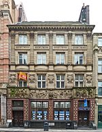
Shops on The Headrow, Leeds (geograph 4035604)

The Headrow is an avenue in Leeds city centre, West Yorkshire, England. It is one of the most important thoroughfares in central Leeds, hosting many of the city's civic and cultural buildings, including Leeds Town Hall, Leeds Central Library, Leeds Art Gallery, The Henry Moore Institute, and The Light. Some of the largest retail floorplates in the city are on The Headrow, particularly between Park Row and Briggate, where major chains have opened flagship stores. The Headrow is part of a longer axis that includes Westgate, Eastgate, and Quarry Hill. The Headrow forms a spine across the city centre between Westgate and Eastgate and is approximately ½ mile (700 m) long. It was widened between 1928 and 1932 in a redevelopment designed by architect Reginald Blomfield, primarily as a way of improving traffic flow through city centre. The area has an advisory speed limit of 15 miles per hour (24 km/h). The section between Park Row and Briggate is reserved for buses and taxis and cars/motorcycles are not permitted to use it between 5 a.m. and 10 p.m.

Excerpt from the Wikipedia article The Headrow (License: CC BY-SA 3.0, Authors, Images).

The Headrow
Albion Street, Leeds Lovell Park

Geographical coordinates (GPS) Address Nearby Places
placeShow on map

Wikipedia: The HeadrowContinue reading on Wikipedia

Geographical coordinates (GPS)

Latitude Longitude
N 53.7995 ° E -1.545 °
placeShow on map

Address

Albion Street

Albion Street
LS2 8TP Leeds, Lovell Park
England, United Kingdom
mapOpen on Google Maps

Shops on The Headrow, Leeds (geograph 4035604)
Share experience

Nearby Places

Leeds
Leeds

Leeds is a city in West Yorkshire, England. It is governed by a metropolitan borough named after the city, which is the third most populous city in the United Kingdom. It is built around the River Aire and is in the eastern foothills of the Pennines. The city was a small manorial borough in the 13th century and a market town in the 16th century. It expanded by becoming a major production centre, including of carbonated water where it was invented in the 1760s, and trading centre (mainly with wool) for the 17th and 18th centuries. It was a major mill town during the Industrial Revolution. It was also known for its flax industry, iron foundries, engineering and printing, as well as shopping, with several surviving Victorian era arcades, such as Kirkgate Market. City status was awarded in 1893, and a populous urban centre formed in the following century which absorbed surrounding villages and overtook the population of nearby York.Leeds is about halfway between London and Edinburgh and has multiple motorway links; the M1, M62 and A1(M). The city's railway station is, alongside Manchester Piccadilly, the busiest of its kind in Northern England. It is the county's largest settlement with a population of 536,280, while the larger City of Leeds district has a population of 812,000 (2021 census). The city is part of the fourth-largest built-up area by population in the United Kingdom, West Yorkshire Built-up Area, with a 2011 census population of 1.7 million.