place

Joralemon Street Tunnel
1908 establishments in New York CityBuildings and structures on the National Register of Historic Places in ManhattanCrossings of the East RiverInterborough Rapid Transit CompanyNew York City Subway infrastructure
Railroad tunnels in New York CityRailway buildings and structures on the National Register of Historic Places in New York CityRailway tunnels on the National Register of Historic PlacesSource attributionTunnels completed in 1908Tunnels in ManhattanUse mdy dates from May 2019
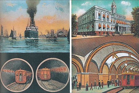
Joralemon Street Tunnel postcard, 1913

The Joralemon Street Tunnel, originally the Brooklyn–Battery Tunnel, is a pair of tubes carrying the IRT Lexington Avenue Line (4 and ​5 trains) of the New York City Subway under the East River between Bowling Green Park in Manhattan and Brooklyn Heights in Brooklyn, New York City. The Joralemon Street Tunnel was an extension of the Interborough Rapid Transit Company (IRT)'s first subway line from the Bowling Green station in Manhattan to the IRT Eastern Parkway Line in Brooklyn. The tubes were constructed using the shield method and are each 6,550 feet (2,000 m) long and 15.5 feet (4.7 m) wide. The interiors are lined with cast-iron "rings" formed with concrete. The tubes descend 91 to 95 feet (28 to 29 m) below the mean high water level of the East River, with a maximum gradient of 3.1 percent. During the tunnel's construction, a house at 58 Joralemon Street in Brooklyn was converted into a ventilation building and emergency exit. The Joralemon Street Tunnel was the first underwater subway tunnel connecting Manhattan and Brooklyn. It was built by the IRT as part of Contract 2, which the IRT signed with the Rapid Transit Commission in 1902. Construction commenced in 1903 and the tubes were completed by 1907, despite various construction accidents and engineering errors that required part of the tunnel to be rebuilt. The first train ran through the Joralemon Street Tunnel in November 1907, and the tunnel opened for passenger service on January 9, 1908. It was listed on the National Register of Historic Places in 2006.

Excerpt from the Wikipedia article Joralemon Street Tunnel (License: CC BY-SA 3.0, Authors, Images).

Joralemon Street Tunnel
East River Esplanade, New York Manhattan

Geographical coordinates (GPS) Address Website Nearby Places
placeShow on map

Wikipedia: Joralemon Street TunnelContinue reading on Wikipedia

Geographical coordinates (GPS)

Latitude Longitude
N 40.696944444444 ° E -74.007222222222 °
placeShow on map

Address

Downtown Manhattan Heliport (Downtown Manhattan/Wall St. Heliport)

East River Esplanade
10041 New York, Manhattan
New York, United States
mapOpen on Google Maps

Website
downtownmanhattanheliport.com

linkVisit website

Joralemon Street Tunnel postcard, 1913
Share experience

Nearby Places

Battery Maritime Building

The Battery Maritime Building is a building at South Ferry on the southern tip of Manhattan Island in New York City. Located at 10 South Street, near the intersection with Whitehall Street, it is composed of an operational ferry terminal at ground level, as well as a hotel and event space on the upper stories. The ground story contains three ferry slips that are used for excursion trips and ferries to Governors Island, as well as commuter trips to Port Liberté, Jersey City. The upper stories contain the Cipriani South Street event space, operated by Cipriani S.A., and are also being converted to a 47-room hotel called Casa Cipriani. The Beaux-Arts building was built from 1906 to 1909 and designed by the firm Walker and Morris as the easternmost section of the partially completed Whitehall Street Ferry Terminal. What is now the Battery Maritime Building was designed to serve ferries traveling to Brooklyn. The structure uses a variety of architectural metals and originally contained a large waiting area on the second floor. The Battery Maritime Building is the only Exposition Universelle-style ferry building still operating in Manhattan. The similarly-designed westernmost section of the Whitehall Street Ferry Terminal, serving ferries to Staten Island, was rebuilt as the Staten Island Ferry Whitehall Terminal; the center section was never built. The terminal was used by Brooklyn ferry routes until the mid-20th century and subsequently fell into disrepair. The building was used as a Governors Island ferry terminal starting in 1956, while the upper floors were used by various city agencies, including the Department of Marine and Aviation beginning in 1959. The New York City Landmarks Preservation Commission designated the building as a city landmark in 1967 and it was added to the National Register of Historic Places in 1976. The underused structure was proposed to be converted into a cultural center during the 1980s as part of the failed South Ferry Plaza development. The exterior was restored by Jan Hird Pokorny Architects between 2001 and 2005. Plans to convert the interior into a hotel and event space were approved in 2009, but the conversion encountered numerous delays, with the event space opening in 2019.