place

Anstey Nomads F.C.

1946 establishments in EnglandAssociation football clubs established in 1946Central AllianceEast Midlands Counties Football LeagueEast Midlands Regional League
Football clubs in EnglandFootball clubs in LeicestershireLeicestershire Senior LeagueNorthern Premier League clubsUnited Counties League

Anstey Nomads Football Club is a football club based in Anstey, Leicestershire, England. They are currently members of the Northern Premier League Division One Midlands and play at Cropston Road.

Excerpt from the Wikipedia article Anstey Nomads F.C. (License: CC BY-SA 3.0, Authors).

Anstey Nomads F.C.
Sheepwash Lane, Charnwood Anstey

Geographical coordinates (GPS) Address Nearby Places
placeShow on map

Wikipedia: Anstey Nomads F.C.Continue reading on Wikipedia

Geographical coordinates (GPS)

Latitude Longitude
N 52.675767 ° E -1.1802873 °
placeShow on map

Address

Sheepwash Lane
LE7 7BL Charnwood, Anstey
England, United Kingdom
mapOpen on Google Maps

Share experience

Nearby Places

Leicestershire
Leicestershire

Leicestershire ( LEST-ər-sheer, -⁠shər) is a ceremonial county in the East Midlands of England. It is bordered by Derbyshire, Nottinghamshire, and Lincolnshire to the north, Rutland to the east, Northamptonshire to the south-east, Warwickshire to the south-west, and Staffordshire to the west. The city of Leicester is the largest settlement and the county town. The county has an area of 2,156 km2 (832 sq mi) and a population of 712,300. Leicester occupies the centre of the county and is by far the largest settlement, with a built-up area population of 357,000. The remainder of the county is largely rural, and the next-largest settlements are Loughborough (65,000), Hinckley (50,000), and Coalville (22,000). For local government purposes Leicestershire comprises a non-metropolitan county with seven districts, and the unitary authority area of Leicester. Leicestershire is generally a lowland county, characterised by small, rolling hills. It is bisected by the River Soar, which rises near the Warwickshire border south of Hinckley and flows north through Leicester and Loughborough before reaching the Trent at the county boundary. To the west of the river is Charnwood Forest, an upland area which contains Bardon Hill, which at 278 m (912 ft) is the county's highest point. There are Prehistoric earthworks in the county, and Leicester was a Roman settlement. The region was settled by the Angles in the sixth century and became part of the Kingdom of Mercia, and the county existed at the time of the Domesday Survey in the 1080s. The county has had a relatively settled existence, however it was the site of the Battle of Bosworth Field in 1485, in which established the Tudor dynasty's position as monarchs of England. During the Industrial Revolution the Leicestershire coalfield in the north and west of the county was exploited. Leicester became known for shoemaking, and with Loughborough continues to be a manufacturing centre. In agriculture the county is known for Stilton cheese and Melton Mowbray pork pies.

Cropston Reservoir
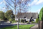
Cropston Reservoir

Cropston Reservoir (originally known as Bradgate Reservoir) lies in Charnwood Forest in Leicestershire, England. The dam and associated water works are in Cropston, while the bulk of the reservoir is in the neighbouring Newtown Linford parish. It was opened in May 1871 in a corner of Bradgate Park, a large expanse of open land northwest of Leicester. It is part of the 987-acre (399.3 ha) Bradgate Park and Cropston Reservoir Site of Special Scientific Interest.London-based consulting engineer Thomas Hawksley was appointed by Leicester Water Works in 1865 to carry out the surveying work. In September 1867, 180 acres (73 ha) of land adjacent to the deer park at Bradgate Park was purchased from the Earl of Stamford for a cost of £24,000. A stone wall was built by George Rudkin around the boundary to separate the deer park from the reservoir, at a cost of 8s 10d per yard. The dam is 760 yards (690 m) long and rises to a height of 51 feet (16 m) at its highest point, which gives a depth of water of 38 feet (12 m). The cost of the dam was £41,356 and the reservoir £8,500 with the contract being awarded to Benton & Woodiwiss of Derby. The reservoir was completed in 1870. The dam was originally constructed from a mixture of siliceous sand and clay, but as water was found to be leaking through it, it was rebuilt and now extends 40 feet (12 m) below the surface. Water from the reservoir was piped to four large filter beds. It was then pumped to an elevation matching the supply from Thornton Reservoir so that the supplies from the two reservoirs could be merged.The reservoir is formed by the River Lin and is owned and managed by Severn Trent. The growing population of Leicester and surrounding areas meant that by the late 19th century the reservoirs in Leicestershire were no longer adequate to meet demand, and water is now piped from Ladybower Reservoir to Cropston.