Malew
EngvarB from September 2015Parishes of the Isle of Man

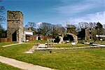
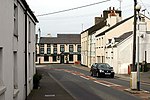
Malew ( mə-LOO; Manx: Malew) is one of the seventeen parishes of the Isle of Man. It is located in the south of the island (part of the traditional South Side division) in the sheading of Rushen. Administratively, part of the historic parish of Malew is now covered by the town of Castletown. As a result, there is a small exclave of the parish district which includes Scarlett point. Other settlements in the parish include Ballasalla, Derbyhaven and St Mark's.
Excerpt from the Wikipedia article Malew (License: CC BY-SA 3.0, Authors, Images).Malew
A34, Malew
Geographical coordinates (GPS) Address Nearby Places Show on map
 Continue reading on Wikipedia
 Geographical coordinates (GPS)
| Latitude | Longitude |
|---|---|
| N 54.116666666667 ° | E -4.6333333333333 ° |
Address
A34
Malew
Isle of Man
Open on Google Maps