place

Central Experimental Farm
1886 establishments in OntarioAgriculture and Agri-Food CanadaAgriculture in OntarioArboreta in CanadaExperimental farms in Canada
Federal government buildings in OttawaNational Historic Sites in OntarioTourist attractions in OttawaUse Canadian English from January 2023
Central Expmtl Farm Ottawa

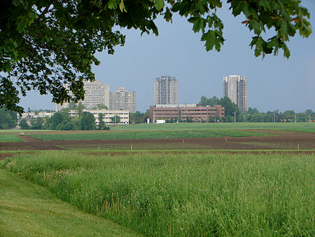
The Central Experimental Farm (CEF), commonly known as the Experimental Farm, is an agricultural facility, working farm, and research centre of the Science and Technology Branch, formerly the Research Branch, of Agriculture and Agri-Food Canada. As the name indicates, this farm is centrally located in and now surrounded by the City of Ottawa, Ontario, Canada. The 4 square kilometres (1.5 sq mi) farm is a National Historic Site of Canada and most buildings are protected and preserved as heritage buildings. The CEF original intent was to perform scientific research for improvement in agricultural methods and crops. While such research is still being conducted, the park-like atmosphere of the CEF has become an important place of recreation and education for the residents of Ottawa. Furthermore, over the years several other departments and agencies have encroached onto the CEF property, such as Natural Resources Canada, National Defence (HMCS Carleton on Dow's Lake), and the Ottawa Civic Hospital (helicopter pad). The CEF is bordered by the Rideau Canal (a National Historic Site as well) to the east, Prince of Wales Drive to the South-East, Baseline Road to the south, and Merivale and Fisher Roads to the west, and Carling Avenue to the north.

Excerpt from the Wikipedia article Central Experimental Farm (License: CC BY-SA 3.0, Authors, Images).

Central Experimental Farm
Cow Lane, (Old) Ottawa River

Geographical coordinates (GPS) Address Nearby Places
placeShow on map

Wikipedia: Central Experimental FarmContinue reading on Wikipedia

Geographical coordinates (GPS)

Latitude Longitude
N 45.382537 ° E -75.713654 °
placeShow on map

Address

Experimental Farm Weather Station

Cow Lane
K1Z 6P7 (Old) Ottawa, River
Ontario, Canada
mapOpen on Google Maps

Central Expmtl Farm Ottawa
Share experience

Nearby Places

Dominion Observatory

The Dominion Observatory was an astronomical observatory in Ottawa, Ontario that operated from 1902 to 1970. The Observatory was also an institution within the Canadian Federal Government. The observatory grew out of the Department of the Interior's need for the precise coordinates and timekeeping that at that time could only come from an observatory. For several years they had used a small observatory on the Ottawa River for this purpose. In 1902, it was decided that Canada needed a larger national observatory similar to the Royal Greenwich Observatory in Britain. Chief Dominion Architect David Ewart designed the Dominion Observatory in 1902.The new building was then erected near Dow's Lake on the Agriculture Department's Central Experimental Farm land. This Romanesque Revival building was completed in 1905. Its main instrument was a 15-inch refracting telescope, the largest refracting telescope ever installed in Canada, although it was not a particularly large telescope for this period. While the building and institution were primarily dedicated to astronomical timekeeping in support of surveying, a number of other activities took place here. The Dominion Observatory was Canada's leading institution in Geophysics for many decades, which included the operation of Canada's national seismometer network. The facility did important work, but with this bridgehead into the world of astronomy and the growth of the field of astrophysics, Canadian astronomers quickly demanded a facility designed for the new scientific age. In 1917, the Dominion Astrophysical Observatory was opened in Victoria, B.C. and it supplanted the Dominion Observatory as Canada's foremost astronomical observatory. For many years, the Dominion Observatory was best known to Canadians as the source of Canada's official time signal. The observatory continued in operation until 1970 at which time Canada's science institutions were reorganized. The national time-keeping and astronomical activities were transferred to the National Research Council of Canada, while the geophysics, surveying and mapping were transferred to the Department of Energy Mines and Resources. The Geophysics work was later merged into the Geological Survey of Canada, now part of Natural Resources Canada. Astronomical timekeeping observations at the Dominion Observatory had ceased many years prior to this, when crystal oscillator clocks and, later, atomic clocks were found to be superior to astronomical timekeeping. The building became home to NRCan offices. The telescope had been open for public viewing from 1905 until 1970. In 1974, the telescope was moved from the Dominion Observatory to the Helen Sawyer Hogg Observatory at the Canada Science and Technology Museum where it remained until 2016.As of 2008, the building is the home to the Office of Energy Efficiency, a part of the Energy Branch, Natural Resources Canada.

Shevchenko Monument (Ottawa)

On The Shevchenko Monument is a bronze and granite monument of Taras Shevchenko, created by Leo Mol, that was unveiled on 26 June 2011 in Ottawa, Ontario, Canada.The composition of the monument includes four items: Taras Shevchenko, and three bas-relief figures complementing the composition. The central monument, sitting on a granite base approximately 8.5 m (28 ft) high, holds a young version of a standing Taras Shevchenko. Dressed in a long coat, the fashion at that time, he holds a palette and three paintbrushes and looks out into the distance. The figure is 3 m (9.8 ft) high and weighs 630 kg (1,390 lb). Three shorter bases hold artistic creations from his poetry. One of the bas-relief figures, standing 1.2 m (3 ft 11 in) and weighing 156 kg (344 lb), represents Haydamaky (referring to Haidamakas) an epic poem of Shevchenko's about the Cossack paramilitary bands that rose up against the szlachta (Polish nobility) in right-bank Ukraine in the 18th-century. The next, Kateryna with child (1.2 m (3 ft 11 in), 163 kg (359 lb)), recalls his early ballad about a Ukrainian girl seduced then abandoned by a Russian - symbolic of the tsarist imposition of serfdom in Ukraine and refers to Shevchenko's painting Kateryna.The last, Banduryst (1.2 m (3 ft 11 in), 156 kg (344 lb)), referring to the Kobzar and Bandura, a traditional Ukrainian stringed musical instrument shaped like a lute. Nearly 90,000 kg (200,000 lb) of Stanstead grey granite from Quebec, was used to create the bases for the monument.The monument is located the grounds of the Saint John the Baptist Ukrainian Catholic Shrine, 952 Green Valley Crescent, Ottawa, Ontario.