Alexandra, New Zealand
Alexandra, New ZealandCentral Otago DistrictClutha RiverPopulated places established in the 1860sPopulated places in Otago ... and 1 more
Use New Zealand English from December 2021

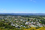
Alexandra (Māori: Manuherikia or Areketanara) is a town in the Central Otago district of the South Island of New Zealand. It is on the banks of the Clutha River (at the confluence of the Manuherikia River), on State Highway 8, 188 kilometres (117 mi) by road from Dunedin and 33 kilometres (21 mi) south of Cromwell. The nearest towns to Alexandra via state highway 8 are Clyde seven kilometres to the northwest and Roxburgh forty kilometres to the south. State highway 85 also connects Alexandra to Omakau, Lauder, Oturehua, Ranfurly and on to Palmerston on the East Otago coast. The town of Alexandra is home to 6,150 people as of June 2024.
Excerpt from the Wikipedia article Alexandra, New Zealand (License: CC BY-SA 3.0, Authors, Images).Alexandra, New Zealand
Campbell Street, Vincent Community Bridge Hill
Geographical coordinates (GPS) Address Nearby Places Show on map
 Continue reading on Wikipedia
 Geographical coordinates (GPS)
| Latitude | Longitude |
|---|---|
| N -45.249166666667 ° | E 169.37972222222 ° |
Address
Campbell Street 5A
9320 Vincent Community, Bridge Hill
Otago, New Zealand
Open on Google Maps