place

Manuherikia River

Otago river stubsRivers of New ZealandRivers of OtagoTributaries of the Clutha RiverUse New Zealand English from April 2024
Manuherikia River Under Another Viaduct

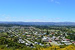
The Manuherikia River is located in Otago in the South Island of New Zealand. It rises in the far north of the Maniototo, with the West Branch draining the eastern side of the St Bathans Range, and the East Branch draining the western flanks of the Hawkdun Range. The river continues southwest through the wide Manuherikia Valley to its confluence with the Clutha River at Alexandra. During the 1860s the Manuherikia was one of the centres of the Otago gold rush. The river is crossed by two historically significant bridges, the curved Manuherikia Bridge No.1 (number 70 on the Otago Central Railway line), a concrete pier bridge completed in 1903, and a stone pier bridge at Ophir built in 1880. The Māori spelling for the river is Manuherekia, meaning "at long last".

Excerpt from the Wikipedia article Manuherikia River (License: CC BY-SA 3.0, Authors, Images).

Manuherikia River
Graveyard Gully Road, Vincent Community Bridge Hill

Geographical coordinates (GPS) Address Nearby Places
placeShow on map

Wikipedia: Manuherikia RiverContinue reading on Wikipedia

Geographical coordinates (GPS)

Latitude Longitude
N -45.266666666667 ° E 169.4 °
placeShow on map

Address

Water treatment plant

Graveyard Gully Road
9320 Vincent Community, Bridge Hill
Otago, New Zealand
mapOpen on Google Maps

Manuherikia River Under Another Viaduct
Share experience

Nearby Places

Clyde, New Zealand
Clyde, New Zealand

Clyde, formerly Dunstan, is a small town in Central Otago, New Zealand with a population of 1,290 in June 2024. It is located on the Clutha River, between Cromwell and Alexandra. Clyde grew up around the former settlement of Dunstan during the Otago gold rush of the 1860s. The town could once claim to be the most populous in New Zealand during the height of gold fever. The town's post office (and thus the town) was officially renamed from Dunstan to Clyde on 22 May 1865, after Lord Clyde. St Dunstan's Church a now heritage building designed by the architect Francis William Petre in the early English Gothic revival style was built in Clyde in 1903. More recently the town has been known for the Clyde Dam, a giant hydroelectric dam at the north end of the town, behind which lies Lake Dunstan. The Clutha River is the swiftest river (per volume) in the southern hemisphere. The river then runs to the Roxburgh Dam before finally meeting the sea at Balclutha. The town is a popular holiday spot. It lies at the western end of the Otago Central Rail Trail. The Otago Central Branch Railway originally terminated at Cromwell, but this section of the railway was closed in 1980, with the railway to Clyde used to bring materials for the dam project. The rail trail is nowadays often cycled and walked by visitors and locals alike. The township is home to Dunstan Hospital, serving the surrounding district, including Alexandra and Cromwell. The hospital was rebuilt in 2006 with the original building remaining. Clyde is fast becoming known as a tourist haven. The location is particularly attractive to those visiting the region's many vineyards and orchards. The regional weather is particularly warm and dry during the summer months due to the rain shadow effect caused by the Southern Alps (given New Zealand's westerly winds). During the week beginning 22 September, the Clyde/Alexandra district hosts a Blossom Festival. This event celebrates the beginning of spring which brings the blossoming of fruit trees in the area's orchards. Entertainment at the festival includes a parade with floats made by local businesses, fun park rides, and bands.