place

Britannia Beach

Company towns in CanadaCopper mines in British ColumbiaDesignated places in British ColumbiaEnvironmental disasters in CanadaMining communities in British Columbia
Pages with undetermined IPAPopulated places in the Squamish-Lillooet Regional DistrictPopulated places on the British Columbia CoastSea-to-Sky CorridorUnincorporated settlements in British ColumbiaUse Canadian English from January 2023Use mdy dates from September 2023Vague or ambiguous time from June 2015
Britannia Beach, British Columbia Location

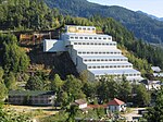
Britannia Beach (Sḵwx̱wú7mesh: Shisháyu7áy, IPA: [ʃɪʃæjʊʔaj]) is a small unincorporated community in the Squamish-Lillooet Regional District located approximately 55 kilometres north of Vancouver, British Columbia on the Sea-to-Sky Highway on Howe Sound. It has a population of about 300. It includes the nearby Britannia Creek, a small to mid-sized stream that flows into Howe Sound that was historically one of North America's most polluted waterways. The community first developed between 1900 and 1904 as the residential area for the staff of the Britannia Mining and Smelting Company. The residential areas and the mining operation were physically interrelated, resulting in coincidental mining and community disasters through its history. Today, the town is host to the Britannia Mine Museum, formerly known as the British Columbia Museum of Mining, on the grounds of the old Britannia Mines. The mine's old Concentrator facilities, used to separate copper ore from its containing rock, are a National Historic Site of Canada.

Excerpt from the Wikipedia article Britannia Beach (License: CC BY-SA 3.0, Authors, Images).

Britannia Beach
Main Street, Area D (Elaho/Garibaldi)

Geographical coordinates (GPS) Address Nearby Places
placeShow on map

Wikipedia: Britannia BeachContinue reading on Wikipedia

Geographical coordinates (GPS)

Latitude Longitude
N 49.625 ° E -123.20416666667 °
placeShow on map

Address

Main Street

Main Street
V0N 1J0 Area D (Elaho/Garibaldi)
British Columbia, Canada
mapOpen on Google Maps

Britannia Beach, British Columbia Location
Share experience

Nearby Places

Britannia Mines Concentrator

The Britannia Mines Concentrator is a National Historic Site of Canada. The large, inclined gravity mill was built on the northwest side of Mount Sheer to assist the transfer of copper ore through the chemical and mechanical processes of the plant. It is a landmark in Britannia Beach, British Columbia some forty-five kilometers north of Vancouver. The nearby volcanic peak of Mount Garibaldi indicates the presence of magmatic inclusions and volcanic cores, in which copper is usually found. As such, the town and mill sit on the western shore of the Britannia Range and defined by the large fjord of Howe Sound. The mining claims were discovered in the 1880s and the Britannia Beach Mining and Smelting Company established in the Edwardian years. Copper was first mined in the area in 1903 and the distance from smelters necessitated the construction of an ore concentrator, a system to deliver ore, and a system to ship the ore concentrate. A primitive concentrator, No. 1, was built in 1904, which was upgraded with two more units, collective known as No.2, built in 1914 and 1915. A fire in 1921 destroyed these, and a concrete and steel structure to house a new concentrator was completed (immediately to the right of the 1914 plant) in early 1923. In the late 1920s, Britannia Mines was the most productive copper mine in the British Empire, and it also produced silver and gold. Now owned by the Britannia Beach Historical Society, it is part of the Britannia Mine Museum.