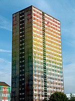
King's Park, Glasgow
Areas of GlasgowGarden suburbsParks and commons in GlasgowUrban public parksUse British English from May 2015

King's Park (Scottish Gaelic: Pàirc an Rìgh, Scots: Keeng's Pairk) is a district in the city of Glasgow, Scotland. It is situated south of the River Clyde and borders the Glasgow areas of Croftfoot, Cathcart, Simshill, Mount Florida and Toryglen and the neighbourhood of Bankhead in the adjoining town of Rutherglen.
Excerpt from the Wikipedia article King's Park, Glasgow (License: CC BY-SA 3.0, Authors, Images).King's Park, Glasgow
Kingshouse Avenue, Glasgow King's Park
Geographical coordinates (GPS) Address Nearby Places Show on map
Geographical coordinates (GPS)
| Latitude | Longitude |
|---|---|
| N 55.821 ° | E -4.241 ° |
Address
King's Park Primary School
Kingshouse Avenue
G44 4JS Glasgow, King's Park
Scotland, United Kingdom
Open on Google Maps


