Malha
Arab villages depopulated during the 1948 Arab–Israeli WarDistrict of JerusalemNeighbourhoods of JerusalemPages with non-numeric formatnum arguments

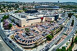
Malha is a neighborhood in southwest Jerusalem, between Pat, Ramat Denya and Kiryat Hayovel in the Valley of Rephaim. Before 1948, Malha was an Arab village known as al-Maliha (Arabic: المالحة).
Excerpt from the Wikipedia article Malha (License: CC BY-SA 3.0, Authors, Images).Malha
HaDishon, Jerusalem Malha
Geographical coordinates (GPS) Address Nearby Places Show on map
Geographical coordinates (GPS)
| Latitude | Longitude |
|---|---|
| N 31.752222222222 ° | E 35.181944444444 ° |
Address
HaDishon 18
9674625 Jerusalem, Malha
Jerusalem District, Israel
Open on Google Maps


