place

Bell Centennial Arena

Buildings and structures in OttawaCanadian ice hockey venue stubsIndoor arenas in OntarioIndoor ice hockey venues in OntarioSports venues in Ottawa
Use mdy dates from June 2013
Center Ice Bell Centennial , August 2008 2013 11 25 18 48

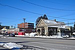
Bell Centennial Arena, also known as Bell Arena for short, is a multi-purpose arena in Bells Corners in Nepean, Ottawa, Ontario, Canada that is located behind Bell High School at 50 Cassidy Drive former Cedarview Road before the new Veterans Memorial Highway (Ontario Highway 416) was built.

Excerpt from the Wikipedia article Bell Centennial Arena (License: CC BY-SA 3.0, Authors, Images).

Bell Centennial Arena
Cassidy Road, Ottawa Nepean

Geographical coordinates (GPS) Address Nearby Places
placeShow on map

Wikipedia: Bell Centennial ArenaContinue reading on Wikipedia

Geographical coordinates (GPS)

Latitude Longitude
N 45.325 ° E -75.810833333333 °
placeShow on map

Address

Cassidy Road 50
K2H 6K1 Ottawa, Nepean
Ontario, Canada
mapOpen on Google Maps

Center Ice Bell Centennial , August 2008 2013 11 25 18 48
Share experience

Nearby Places

Queensway Carleton Hospital

Queensway Carleton Hospital (QCH) is a 355-bed hospital located in the west end of Ottawa, Ontario, Canada that delivers acute care and is west Ottawa's only full-service hospital. QCH was officially opened on October 5, 1976, by then Ontario Premier William Davis and currently serves a population of more than 500,000 and is the secondary referral center for the Ottawa Valley. QCH focuses on its cornerstone health care programs: emergency, childbirth, Geriatric, mental health, rehabilitation, medical and surgical, and critical care.In 2015 QCH obtained its "Accreditation with Exemplary Standing" from Accreditation Canada, the highest award level of accreditation with an overall compliance score of 99.4 (2014/2026 compliant standards) and meeting all 31/31 Required Organizational Practices.The executive management team is led by President and chief executive officer Dr. Andrew Falconer and the medical team reports to Chief of Staff Dr. Katalin Kovacs. Dr. Falconer replaced Tom Schonberg who died in February 2019.In fiction, The hospital was mentioned in the episode The Smile in “Homeland” where the character Carrie Mathison, received a temporary new identity, “Kate Morrissey”, for a CIA mission, with one of the facts of Morrissey being born in the hospital. However, the hospital did not have a maternity ward at the time of her birth and her place of birth is incorrectly listed as Ottawa when at that time the hospital within Nepean (before amalgamation of the city of Ottawa).

Qualicum-Graham Park

Qualicum-Graham Park or Qualicum is a suburban neighbourhood in College Ward in the City of Ottawa, Ontario, Canada. It is located in the former City of Nepean in the west end of the city. Many of the residences in the area are executive homes situated on large lots (100x100) being built in the 1960s. Qualicum Street boasts large custom houses built by Bill Teron. The neighbourhood is bounded to the north by the Queensway, to the west by Richmond Road, to the south by Baseline Road, and to the east by Morrison Drive at the former Ottawa-Nepean border towards Redwood. Named after Qualicum Beach in British Columbia. According to the Canada 2011 Census, the total population of the neighbourhood was 1,715.Most of the streets are named after Aboriginal peoples and towns in British Columbia. The following streets are located in the community: Aleutian Road- named after the Aleutian Islands in Alaska. Chinook Crescent- the Chinook winds in the Canadian Prairies. Cowichan Way- named after the Cowichan peoples in BC. Esquimalt Avenue- a town on Vancouver Island. One of the main streets in the neighborhood; starts at Beaumaris and ends at Okanagan Kitimat Crescent-Town in northwestern British Columbia Kitsilano Court- Named after a suburb in Vancouver, British Columbia. Located at the former Graham Park Public School grounds in Qualicum-Graham Park. Built in 2015. Mohawk Crescent- Named after the Mohawk people. The tribe is located in the St. Lawrence Region; Southern Quebec, Eastern Ontario, and Northern New York. Nanaimo Drive-A town in Vancouver Island. Another main street in the neighbourhood. Okanagan Drive- Named after the Okanagan Valley around the Rocky Mountains in BC. Starts at Nanaimo Drive, which curves and ends at Baseline Road. Qualicum Street- Named after Qualicum Beach on Vancouver Island. Qualicum street is parallel along Baseline Road. Starts at Draper Avenue and ends at Esquimalt Avenue. Sioux Crescent- Named after the Sioux in the Northern United States(Minnesota, Dakotas, Iowa and Montana) and the Prairies in Central Canada (Alberta, Manitoba and Saskatchewan).