place

St. John's African Methodist Episcopal Church (Norfolk, Virginia)

African-American history of VirginiaAfrican Methodist Episcopal churches in VirginiaChurches completed in 1888Churches in Norfolk, VirginiaChurches on the National Register of Historic Places in Virginia
Hampton Roads, Virginia Registered Historic Place stubsNational Register of Historic Places in Norfolk, VirginiaReligious organizations established in 1840Romanesque Revival church buildings in VirginiaVirginia church stubs
St. John's African Methodist Episcopal Church

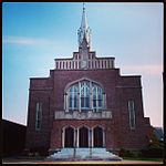
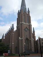
St. John's AME Church is a historic congregation of the African Methodist Episcopal Church in Norfolk, Virginia, United States. Founded in 1840, it was the first African American Episcopal Church in Virginia. It moved to its present location on East Bute Street in what is now Downtown Norfolk in 1848.The historic church building was built in 1888, a red brick structure in the Richardsonian Romanesque style with a large, heavy and steeply pitched slate roof and two flanking towers. The building features a centered stone entrance portico, containing the main entrance to the church. The portico is built of light grey freestone in a style reminiscent of the ambulatory of a Romanesque abbey and consists of two large openings headed by semi-circular arches. The building houses a large sanctuary and horseshoe-shaped balcony with a seating capacity of 1,500 people. Also on the property is the contributing parsonage; a 2½-story, four-bay, brick dwelling in a simplified Second French Empire style. It was listed on the National Register of Historic Places in 1986.

Excerpt from the Wikipedia article St. John's African Methodist Episcopal Church (Norfolk, Virginia) (License: CC BY-SA 3.0, Authors, Images).

St. John's African Methodist Episcopal Church (Norfolk, Virginia)
Wood Street, Norfolk

Geographical coordinates (GPS) Address Nearby Places
placeShow on map

Wikipedia: St. John's African Methodist Episcopal Church (Norfolk, Virginia)Continue reading on Wikipedia

Geographical coordinates (GPS)

Latitude Longitude
N 36.851666666667 ° E -76.282777777778 °
placeShow on map

Address

Wood Street 523
23510 Norfolk
Virginia, United States
mapOpen on Google Maps

St. John's African Methodist Episcopal Church
Share experience

Nearby Places

Norfolk Scope
Norfolk Scope

Norfolk Scope is a multi-function complex in Norfolk, Virginia, comprising an 11,000-person arena, a 2,500-person theater known as Chrysler Hall, a 10,000-square-foot (930 m2) exhibition hall and a 600-car parking garage. The arena was designed by Italian architect/engineer Pier Luigi Nervi in conjunction with the (now defunct) local firm Williams and Tazewell, which designed the entire complex. Nervi's design for the arena's reinforced concrete dome derived from the PalaLottomatica and the much smaller Palazzetto dello Sport, which were built in the 1950s for the 1960 Summer Olympics in Rome. Construction on Scope began in June 1968 at the northern perimeter of Norfolk's downtown and was completed in 1971 at a cost of $35 million. Federal funds covered $23 million of the cost, and when it opened formally on November 12, 1971, the structure was the second-largest public complex in Virginia, behind only the Pentagon.Featuring the world's largest reinforced thinshell concrete dome (though eclipsed by the Seattle Kingdome from 1976 to 2000), Scope won the Virginia Society of the American Institute of Architects Test of Time award in 2003. Wes Lewis, director of Old Dominion University's civil engineering technology program, called it "a beautiful marrying of art and engineering." Noted architectural critic James Howard Kunstler described the design as looking like "yesterday's tomorrow."The name "Scope", a contraction of kaleidoscope, emphasizes the venue's re-configurability. The facility logo (right), which features a multi-colored, abstracted kaleidoscope image, was designed by Raymond Loewy's firm Loewy/Snaith of New York.

Downtown Norfolk, Virginia

Downtown Norfolk serves as the traditional center of commerce, government, and culture in the Hampton Roads region. Norfolk, Virginia's downtown waterfront shipping and port activities historically played host to numerous and often noxious port and shipping-related uses. With the advent of containerized shipping in the mid-19th century, the shipping uses located on Norfolk's downtown waterfront became obsolete as larger and more modern port facilities opened elsewhere in the region. The vacant piers and cargo warehouses eventually became a blight on downtown and Norfolk's fortunes as a whole. But in the second half of the century, Norfolk had a vibrant retail community in its suburbs; companies like Smith & Welton, High's, Colonial Stores, Goldman's Shoes, Lerner Shops, Hofheimer's, Giant Open Air, Dollar Tree and K & K Toys were regional leaders in their respective fields. Norfolk was also the birthplace of Econo-Travel, now Econo Lodge, one of the nation's first discount motel chains. Similarly, the advent of newer suburban shopping destinations spelled demise for the fortunes of downtown's Granby Street commercial corridor, located just a few blocks inland from the waterfront. Granby Street traditionally played the role as the premiere shopping and gathering spot in the Hampton Roads region. Retailers ranged from low-priced variety stores such as Woolworth's and Grants to more upscale department stores such as Smith & Welton (1898–1988), Rices Nachmans (1918–1985) and Ames and Brownley (1898–1973), and fine hotels and theaters lined its sidewalks. However, new suburban shopping developments promised more convenience and comfort. The opening of Pembroke Mall in Virginia Beach, the region's first climate controlled shopping mall, and JANAF Shopping Center in Norfolk's Military Circle area, helped foment Granby Street's spiral into commercial obsolescence. With amenities such as ample free parking at the door of one's favorite store, and in the case of Pembroke Mall, climate control, the businesses of downtown's Granby Street found it harder and harder to compete. Beginning in the 1920s, Norfolk's city leaders began what would be a long push to revive the fortunes of its urban core.

Norfolk, Virginia
Norfolk, Virginia

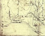
Norfolk ( NOR-fuk) is an independent city in Virginia, United States. As of the 2020 census, Norfolk had a population of 238,005, making it the third-most populous city in Virginia after neighboring Virginia Beach and Chesapeake, and the 95th-most populous city in the nation. Norfolk holds a strategic position as the historical, urban, financial, and cultural center of the Hampton Roads region (sometimes called "Tidewater"), which has more than 1.8 million inhabitants and is the 37th-largest metropolitan area in the U.S., with ten cities.Norfolk was incorporated in 1705. Bordered to the west by the Elizabeth River and to the north by the Chesapeake Bay, the city shares land borders with the independent cities of Chesapeake to its south and Virginia Beach to its east. With coastline along multiple bodies of water, Norfolk has many miles of riverfront and bayfront property, including beaches on the Chesapeake Bay. The coastal zones are important for the economy. The largest naval base in the world, Naval Station Norfolk, is located in Norfolk along with one of NATO's two Strategic Command headquarters. Additionally, Norfolk is an important contributor to the Port of Virginia. It is home to Maersk Line, Limited, which manages the world's largest fleet of US-flag vessels. This low-lying coastal infrastructure is very vulnerable to sea level rise, with water levels expected to rise by more than 5.5 feet (1.7 meters) by the end of the 21st century. The city has a long history as a strategic military and transportation point, where many railroad lines started. It is linked to its neighbors by an extensive network of interstate highways, bridges, tunnels, and three bridge-tunnel complexes.