The Braaid
History of the Isle of ManIsle of Man geography stubs

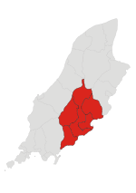
The Braaid is an Iron Age roundhouse and two Norse long houses on this site represent its occupation until the 11th or 12th century AD in the parish of Marown in the Isle of Man. The site uniquely brings together buildings of Iron Age and Viking styles that were used together and survive down to the present. The site lies between Braaid hamlet and Mount Murray at which reference an area map can be viewed. Also nearby is The Broogh Fort (54°08′09″N 4°34′39″W).
Excerpt from the Wikipedia article The Braaid (License: CC BY-SA 3.0, Authors, Images).The Braaid
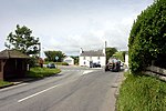
Foot path to 'The Braaid' Manx National Heritage Monument, Marown
Geographical coordinates (GPS) Address External links Nearby Places Show on map
 Continue reading on Wikipedia
 Geographical coordinates (GPS)
| Latitude | Longitude |
|---|---|
| N 54.15725 ° | E -4.5665555555556 ° |
Address
The Braaid
Foot path to 'The Braaid' Manx National Heritage Monument
Marown
Isle of Man
Open on Google Maps
External links